Windberg (Freital)
The Windberg (353 m above NN) is a hill in the borough of Freital near Dresden in the German federal state of Saxony. It is the town's Hausberg or local hill.
| Windberg | |
|---|---|
 | |
| Highest point | |
| Elevation | 353 m (1,158 ft) |
| Coordinates | 50°59′49″N 13°39′39″E |
| Geography | |
| Parent range | Döhlen Basin |
| Geology | |
| Age of rock | Rotliegendes |
| Mountain type | conglomerate with hard coal seams |
Geomorphology and natural features
The Windberg has a striking silhouette, visible from afar. Its narrow northwestern slope opens out into a long, broad and thickly wooded plateau. The hill has been designated as a nature reserve and protected area since 1967 due to its near-natural woodland and rich flora and fauna. Its tectonic cleft cavern, known as the Windbergspalte,[1] is the deepest cave in Saxony with a depth of 44 metres (144 ft).
Gallery
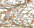 Section of an 1895 overview map with the Windberg
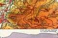 1930 topographical map of the Windberg with contours
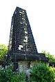 King Albert Monument on the Windberg
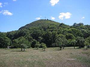
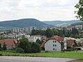 View from Freital-Wurgwitz of the Windberg
gollark: There's even a Ubuntu Touch GSI, and maybe eventually a postmarketOS one will happen.
gollark: On the plus side, Project Treble means that the drivers/hardware mess on ARM is somewhat mitigated, and you can flash generic-system-image ROMs on most modern devices which allow bootloader unlocking and have stuff mostly work.
gollark: I like having a smartphone and would really not want to not have one, but oh something or other the software choices are so awful.
gollark: They probably receive money™ to do so.
gollark: Basically that. Although it's not that much work if you have... basic familiarity with command prompts and such?
References
- Sächsischer Höhlenkataster Nr. 5047/EG-12
Sources
- Haus der Heimat Freital (Hg.): Der Windberg, Freital 1986
This article is issued from Wikipedia. The text is licensed under Creative Commons - Attribution - Sharealike. Additional terms may apply for the media files.