Wiedau
Wiedau is a river of Lower Saxony, Germany. It is a left-hand tributary of the Wümme.
| Wiedau | |
|---|---|
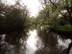
 The Wiedau in Rotenburg | |
| Location | |
| Country | Germany |
| State | Lower Saxony |
| Physical characteristics | |
| Source | |
| • location | confluence of the Hahnenbach and Mehlandsbach near Bellen (a district of Brockel) |
| • coordinates | 53°03′50″N 9°34′21″E |
| • elevation | 33 m |
| Mouth | |
• location | near Rotenburg into the Wümme |
• coordinates | 53°06′26″N 9°23′25″E |
• elevation | 18 m |
| Length | 14.2 km (8.8 mi) (including the river Mehlandsbach: 27.4 km (17.0 mi))[1] |
| Basin size | 307 km2 (119 sq mi)[1] |
| Discharge | |
| • average | ca. 3.0 m3/s (110 cu ft/s); before it joins the Rodau: 1.6 m3/s (57 cu ft/s) |
| Basin features | |
| Progression | Wümme→ Lesum→ Weser→ North Sea |
| Landmarks | |
The Wiedau begins near Bellen (a district of Brockel) in the vicinity of Hemslingen in the district of at the confluence of the Hahnenbach and the Mehlandsbach. In the area the Samtgemeinde Bothel, it flows through a densely wooded and near natural depression. It discharges into the Wümme in Rotenburg shortly after being joined by the only slightly smaller Rodau.
Water sport
The Wiedau is popular with anglers and canoeists. At high water, the Wiedau can be navigated from the road bridge in Bellen near Hemslingen to its mouth on the Wümme by small kayaks, a distance of 23 km (14 mi).
gollark: Although vector graphics would often be nicer, they're not always practical.
gollark: It's perfectly fine for other things where you can get nice small images with little perceptible quality loss.
gollark: Thus, small lossily compressed files.
gollark: It uses the interframe compression format.
gollark: Yes, it's good.
See also
This article is issued from Wikipedia. The text is licensed under Creative Commons - Attribution - Sharealike. Additional terms may apply for the media files.