Wevok, Alaska
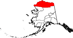
Wevok is a former Iñupiat village in the western part of North Slope Borough in the U.S. state of Alaska.
Wevok, Alaska | |
|---|---|
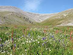
 Wildflowers on Cape Lisburne | |
 Wevok, Alaska Location within the state of Alaska | |
| Coordinates: 68°52′19″N 166°5′25″W | |
| Country | United States |
| State | Alaska |
| Borough | North Slope |
| Government | |
| • Borough mayor | Harry K. Brower, Jr. |
| • State senator | Donny Olson (D) |
| • State rep. | Dean Westlake (D) |
| Elevation | 56 ft (17 m) |
| Time zone | UTC-9 (Alaska (AKST)) |
| • Summer (DST) | UTC-8 (AKDT) |
Its name is derived from the Iñupiat name of Cape Lisburne, which is 5 km (3.1 mi) to the west. Its maximum elevation is 17 m (56 ft).[1]
Demographics
| Historical population | |||
|---|---|---|---|
| Census | Pop. | %± | |
| 1880 | 13 | — | |
| U.S. Decennial Census[2] | |||
Wevok appeared once on the 1880 U.S. Census as "Cape Lisburne", an unincorporated Inuit village of 13 residents (all Inuit).[3] The village did not report again on the census.
gollark: Don't worry, if you get banned for some minor detail then the ensuing forum salt will probably stop it happening.
gollark: Unless there's a trade for a thing you want quite a lot, in which case maybe do offer on it.
gollark: Prizes breed prizes more often than they *should* based on their rarity.
gollark: Rare as determined by breeding ratio or whatever, though?
gollark: As I always say, "hunting is very annoying".
References
- "Wevok, Alaska". Geographic Names Information System. United States Geological Survey.
- "U.S. Decennial Census". Census.gov. Retrieved June 6, 2013.
- http://www2.census.gov/prod2/decennial/documents/1880a_v1-17.pdf
This article is issued from Wikipedia. The text is licensed under Creative Commons - Attribution - Sharealike. Additional terms may apply for the media files.
