West Dolores River
The West Dolores River is a 35.0-mile-long (56.3 km)[2] tributary of the Dolores River, in southwestern Colorado in the United States. Its source is northeast of Mount Wilson in the Lizard Head Wilderness of Dolores County, Colorado. The river flows southwest to a confluence with the Dolores in Montezuma County.
| West Dolores River[1] | |
|---|---|
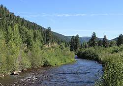 The river just before its confluence with the Dolores River. | |
| Physical characteristics | |
| Source | |
| • coordinates | 37°50′50″N 108°00′10″W |
| Mouth | |
• location | Confluence with Dolores River |
• coordinates | 37°35′13″N 108°21′35″W |
• elevation | 7,369 ft (2,246 m) |
| Basin features | |
| Progression | Dolores—Colorado |
References
- "West Dolores River". Geographic Names Information System. United States Geological Survey. Retrieved 2011-01-31.
- U.S. Geological Survey. National Hydrography Dataset high-resolution flowline data. The National Map, accessed March 18, 2011
This article is issued from Wikipedia. The text is licensed under Creative Commons - Attribution - Sharealike. Additional terms may apply for the media files.