Weida, Thuringia
Weida is a town in the district of Greiz, in Thuringia, Germany, situated 12 km south of Gera on the river Weida.
Weida | |
|---|---|
 | |
 Coat of arms | |
Location of Weida within Greiz district 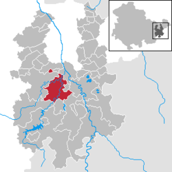 | |
 Weida  Weida | |
| Coordinates: 50°46′30″N 12°3′25″E | |
| Country | Germany |
| State | Thuringia |
| District | Greiz |
| Subdivisions | 2 |
| Government | |
| • Mayor | Heinz Hopfe[1] |
| Area | |
| • Total | 36.48 km2 (14.09 sq mi) |
| Elevation | 231 m (758 ft) |
| Population (2018-12-31)[2] | |
| • Total | 8,472 |
| • Density | 230/km2 (600/sq mi) |
| Time zone | CET/CEST (UTC+1/+2) |
| Postal codes | 07565–07570 |
| Dialling codes | 036603 |
| Vehicle registration | GRZ |
| Website | www.weida.de |
History
Within the German Empire (1871-1918), Weida was part of the Grand Duchy of Saxe-Weimar-Eisenach.
The Eisenhammer Weida is an historic hammer mill.
 The Osterburg and city of Weida
 The Oschütztal-Viadukt in Weida
gollark: 2.0 of what? What does it have? Why do you need it?
gollark: ↓ weaponized rustc
gollark: Never mind, it's just hilariously slow.
gollark: Hmm. It appears that my dokuwiki install has undergone "beeing".
gollark: And they're always sane and able to reasonably decide on things!
References
- https://www.weida.de/stadtverwaltung/
- "Bevölkerung der Gemeinden, erfüllenden Gemeinden und Verwaltungsgemeinschaften nach Geschlecht in Thüringen Gebietsstand: 31.12.2018". Thüringer Landesamt für Statistik (in German). September 2019.
External links
- Landkreis Greiz (in English, German, and French)
| Authority control |
|
|---|
This article is issued from Wikipedia. The text is licensed under Creative Commons - Attribution - Sharealike. Additional terms may apply for the media files.