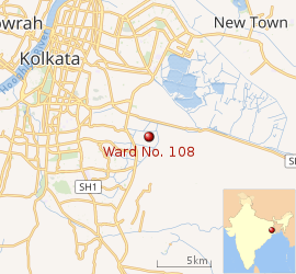
Ward No. 108, Kolkata Municipal Corporation
Ward No. 108, Kolkata Municipal Corporation is an administrative division of Kolkata Municipal Corporation in Borough No. 12, covering parts of VIP Nagar, Jagorani colony (Gouranga Pally-Matongini Colony), Uttar Panchanna Gram (Martin Para-Gulshan Colony), Paschim Chowbaga, Sardarhat, Chowbaga, Bantala, Adarsha Nagar, Nonadanga, Mundapara and East Calcutta Township (Ruby-Anandapur-Nazirabad-Urbana-Hussainpur-Madurdaha) neighbourhoods in South Kolkata in the Indian state of West Bengal.
Ward No. 108 | |
|---|---|
Kolkata Municipal Corporation | |
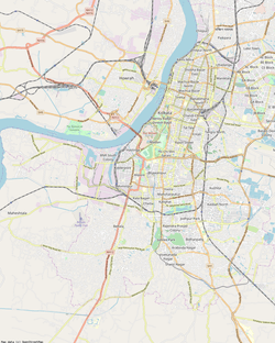 Ward No. 108 Location in Kolkata | |
| Coordinates (dms): 22.522133°N 88.409694°E | |
| Country | |
| State | West Bengal |
| City | Kolkata |
| Neighbourhoods | VIP Nagar, jagorani colony (Gouranga Pally-Matongini Colony), Uttar Panchanna Gram (Martin Para-Gulshan Colony), Paschim Chowbaga, Sardarhat, Chowbaga, Bantala, Adarsha Nagar, Nonadanga, Mundapara, East Calcutta Township (Ruby-Anandapur-Nazirabad-Urbana-Hussainpur-Madurdaha) |
| Parliamentary constituency | Kolkata Dakshin |
| Assembly constituency | Kasba |
| Borough | 12 |
| Population (2011) | |
| • Total | 64,777 |
| Time zone | UTC+5:30 (IST) |
| PIN | 700 100 |
| Area code(s) | +91 33 |
 |
| Ward No. 108 in Kolkata |
History
The establishment and evolution of Kolkata Municipal Corporation followed a long process starting from around the middle of the 19th century. The Municipal Consolidation Act of 1888 and certain steps taken thereafter saw the addition of peripheral areas in the eastern and southern parts of the city to the corporation area. In 1888, there were 75 commissioners, 50 of whom were elected, 15 appointed by the government and 10 nominated from bodies like Chambers of Commerce, Trades Associations and the Port Commissioners. The Calcutta Municipal Act of 1923 brought about important changes. The adjacent municipalities of Cossipore, Chitpore, Manicktola and Garden Reach, as well as the New Dock Extension area, were amalgamated with Kolkata. Garden Reach was later taken out.[1][2]
Post-independence developments saw the introduction of adult franchise in municipal elections in 1962. The number of wards increased from 75 to 100. Tollygunge was merged with Kolkata in 1953. The Calcutta Municipal Corporation Act 1980, which came into effect in 1984, extended the boundaries of Kolkata by including South Suburban, Garden Reach and Jadavpur municipalities in Kolkata. With the addition of Joka to Kolkata, the number of wards rose to 144.[1][2]
Geography
Ward No. 108 is bordered on the north by the northern boundary of Nonadanga mauza, storm water outlet and northern boundary of Dhapa mauza; on the east by the eastern boundaries of Madurdaha, Nonadanga and Dhapa mauzas; on the south by the northern boundary of Kalikapur mauza and southern boundaries of Chowbhaga and Dhapa mauzas; and on the west by Eastern Metropolitan Bypass.[3]
The ward is served by Tiljala, Anandapur, Pragati Maidan and Kolkata Leather Complex police stations of Kolkata Police.[4][5][6]
Karaya Women police station, has jurisdiction over all police districts under the jurisdiction of the South East Division, i.e. Topsia, Beniapukur, Ballygunge, Gariahat, Lake, Karaya, Rabindra Sarobar and Tiljala.[4]
Demographics
As per the 2011 Census of India, Ward No. 108, Kolkata Municipal Corporation, had a total population of 64,777, of which 33,428 (52%) were males and 31,349 (48%) were females. Population below 6 years was 7,204. The total number of literates in Ward No. 108 was 46,487 (80.74% of the population over 6 years).[7]
Kolkata is the second most literate district in West Bengal.[8] The literacy rate of Kolkata district has increased from 53.0% in 1951 to 86.3% in the 2011 census.[9]
See also – List of West Bengal districts ranked by literacy rate
| Literacy in KMC wards |
|---|
| North Kolkata |
| Ward No. 1 – 86.12% |
| Ward No. 2 – 94.24% |
| Ward No. 3 – 86.74% |
| Ward No. 4 – 89.27% |
| Ward No. 5 – 90.32% |
| Ward No. 6 – 81.12% |
| Ward No. 7 – 87.65% |
| Ward No. 8 – 93.57% |
| Ward No. 9 – 91.60% |
| Ward No. 10 – 92.38% |
| Ward No. 11 – 87.96% |
| Ward No. 12 – 84.95% |
| Ward No. 13 – 83.39% |
| Ward No. 14 – 87.87% |
| Ward No. 15 – 88.89% |
| Ward No. 16 – 88.62% |
| Ward No. 17 – 92.30% |
| Ward No. 18 – 78.72% |
| Ward No. 19 – 89.29% |
| Ward No. 20 – 85.93% |
| Ward No. 21 – 78.12% |
| Ward No. 22 – 85.07% |
| Ward No. 23 – 71.14% |
| Ward No. 24 – 73.16% |
| Ward No. 25 – 85.49% |
| Ward No. 26 – 82.34% |
| Ward No. 27 – 88.19% |
| Ward No. 28 – 79.39% |
| Ward No. 29 – 70.69% |
| Ward No. 30 – 88.71% |
| Ward No. 31 – 88.28% |
| Ward No. 32 – 75.73% |
| Ward No. 33 – 91.17% |
| Central Kolkata |
| Ward No. 34 – 92.79% |
| Ward No. 35 – 91.44% |
| Ward No. 36 – 66.34% |
| Ward No. 37 – 79.12% |
| Ward No. 38 – 85.77% |
| Ward No. 39 – 73.27% |
| Ward No. 40 – 88.14% |
| Ward No. 41 – 83.53% |
| Ward No. 42 – 75.02% |
| Ward No. 43 – 79.52% |
| Ward No. 44 – 79.09% |
| Ward No. 45 – 74.69% |
| Ward No. 46 – 85.38% |
| Ward No. 47 – 87.87% |
| Ward No. 48 – 82.04% |
| Ward No. 49 – 65.51% |
| Ward No. 50 – 88.70% |
| Ward No. 51 – 93.01% |
| Ward No. 52 – 86.18% |
| Ward No. 53 – 89.49% |
| Ward No. 54 – 82.10% |
| Ward No. 55 – 84.84% |
| Ward No. 56 – 85.53% |
| Ward No. 57 – 80.20% |
| Ward No. 58 – 74.35% |
| Ward No. 59 – 80.39% |
| Ward No. 60 – 44.16% |
| Ward No. 61 – 80.54% |
| Ward No. 62 – 86.04% |
| Ward No. 63 – 84.39% |
| Ward No. 64 – 85.21% |
| Ward No. 65 – 81.60% |
| South Kolkata |
| Ward No. 66 – 80.95% |
| Ward No. 67 – 89.52% |
| Ward No. 68 – 90.86% |
| Ward No. 69 – 86.07% |
| Ward No. 70 – 94.20% |
| Ward No. 71 – 92.01% |
| Ward No. 72 – 90.06% |
| Ward No. 73 – 89.28% |
| Ward No. 74 – 84.56% |
| Ward No. 75 – 80.27% |
| Ward No. 76 – 88.40% |
| Ward No. 77 – 83.84% |
| Ward No. 78 – 83.00% |
| Ward No. 79 – 81.96% |
| Ward No. 80 – 71.89% |
| Ward No. 81 – 85.14% |
| Ward No. 82 – 84.82% |
| Ward No. 83 – 85.63% |
| Ward No. 84 – 85.71% |
| Ward No. 85 – 88.19% |
| Ward No. 86 – 89.61% |
| Ward No. 87 – 90.26% |
| Ward No. 88 – 85.09% |
| Ward No. 89 – 92.40% |
| Ward No. 90 – 84.60% |
| Ward No. 91 – 90.57% |
| Ward No. 92 – 93.53% |
| Ward No. 93 – 91.30% |
| Ward No. 94 – 89.11% |
| Ward No. 95 – 95.61% |
| Ward No. 96 – 96.57% |
| Ward No. 97 – 94.60% |
| Ward No. 98 – 96.24% |
| Ward No. 99 – 95.79% |
| Ward No. 100 – 95.98% |
| Ward No. 101 – 95.36% |
| Ward No. 102 – 93.53% |
| Ward No. 103 – 94.77% |
| Ward No. 104 – 96.03% |
| Ward No. 105 – 93.86% |
| Ward No. 106 – 92.97% |
| Ward No. 107 – 90.06% |
| Ward No. 108 – 80.74% |
| Ward No. 109 – 85.49% |
| Ward No. 110 – 91.35% |
| Ward No. 111 – 93.36% |
| Ward No. 112 – 92.50% |
| Ward No. 113 – 92.18% |
| Ward No. 114 – 91.13% |
| Ward No. 115 – 95.53% |
| Ward No. 116 – 86.91% |
| Ward No. 117 – 86.53% |
| Ward No. 118 – 90.04% |
| Ward No. 119 – 94.04% |
| Ward No. 120 – 92.15% |
| Ward No. 121 – 91.86% |
| Ward No. 122 – 92.88% |
| Ward No. 123 – 93.42% |
| Ward No. 124 – 92.55% |
| Ward No. 125 – 92.50% |
| Ward No. 126 – 93.78% |
| Ward No. 127 – 91.82% |
| Ward No. 128 – 92.67% |
| Ward No. 129 – 92.56% |
| Ward No. 130 – 95.55% |
| Ward No. 131 – 93.48% |
| Ward No. 132 – 90.30% |
| Ward No. 133 – 83.48% |
| Ward No. 134 – 73.75% |
| Ward No. 135 – 75.75% |
| Ward No. 136 – 85.01% |
| Ward No. 137 – 79.16% |
| Ward No. 138 – 78.67% |
| Ward No. 139 – 77.56% |
| Ward No. 140 – 79.93% |
| Ward No. 141 – 75.15% |
| Note: The regional distribution is a broad one and there is some overlapping |
| Source: 2011 Census: Ward-Wise Primary Census Abstract Data |
Census data about mother tongue and religion is not available at the ward level. For district level information see Kolkata district.
According to the District Census Handbook Kolkata 2011, 141 wards of Kolkata Municipal Corporation formed Kolkata district. (3 wards were added later).[10]
Election highlights
The ward forms a city municipal corporation council electoral constituency and is a part of Kasba (Vidhan Sabha constituency).[11]
| Election year | Constituency | Name of councillor | Party affililiation | |
|---|---|---|---|---|
| 2005 | Ward No. 108 | Amal Mazumdar | Communist Party of India (Marxist) | [12] |
| 2010 | Partha Roy Chowdhury | All India Trinamool Congress | [13] | |
| 2015 | Shyamal Banerjee | All India Trinamool Congress | [14][15] |
| Kolkata Municipal Corporation election 2015 summary | ||
|---|---|---|
| Party | Seats won | Seat change |
| All India Trinamool Congress | 123 (116+7) | |
| Left Front | 13 (15-2) | |
| Bharatiya Janata Party | 4 (5-1) | |
| Indian National Congress | 2 (5-3) | |
| Independents | 1 (3-2) | |
Source: DNA West Bengal Municipal Election Results, 28 April 2015
External links
![]()
![]()
References
- "A walk down memory lane". About Kolkata. KMC. Retrieved 16 February 2018.
- "Kolkata Municipal Corporation". Kolkata - a municipal history. KMC. Retrieved 16 February 2018.
- "Municipal Wards". Yellow Pages.com. Retrieved 4 June 2015.
- "Kolkata Police, South-east Division". Tiljala police station. KP. Retrieved 28 February 2018.
- Kolkata: Detail Maps of 141 Wards with Street Directory, Fourth Impression 2003, Map No. 78, D.P. Publication and Sales Concern, 66 College Street, Kolkata-700 073.
- "Table 3 District Wise List of Statutory Towns (Municipal Corporation, Municipality, Notified Area and Cantonment Board), Census Towns and Outgrowths, West Bengal, 2001". Census of India 2001. Census Commission of India. Archived from the original on 21 July 2011. Retrieved 12 February 2018.
- "2011 Census – Primary Census Abstract Data Tables". West Bengal – District-wise. Registrar General and Census Commissioner, India. Retrieved 12 February 2018l.
- "District Census Handbook Kolkata, Census of India 2011, Series 20, Part XII B" (PDF). Page 25: District Highlights, 2011 Census. Directorate of Census Operations, West Bengal. Retrieved 15 February 2018.
- "District Census Handbook Kolkata, Census of India 2011, Series 20, Part XII A" (PDF). Pages 63-64: Literacy Rate. Directorate of Census Operations, West Bengal. Retrieved 15 February 2018.
- "District Census Handbook Kolkata, Census of India 2011, Series 20, Part XII A" (PDF). Map on third page plus demographic data about all the wards in the handbook. Directorate of Census Operations, West Bengal. Retrieved 15 February 2018.
- "Delimitation Commission Order No. 18 dated 15 February 2006" (PDF). West Bengal. Election Commission. Retrieved 4 June 2015.
- Search the web for COUNCILLORS OF KOLKATA MUNICITIPAL CORPORATION. In the search list click on this. On clicking one gets an option for "List of KMC Councillors" at the bottom of the page. Press <Open> to get to Adobe Acrobat file.
- "Kolkata Municipal Corporation General Election Results 2010". Government of West Bengal. Retrieved 4 June 2015.
- Prabahat Khabar, Hindi newspaper, print edition, 29 April 2015
- "Ward-wise winners" (PDF). Gazette Notification. West Bengal State Election Commission. Retrieved 4 June 2015.
| Wards |
|
|---|---|
| Related topics |
|
| See also |
|