War Eagle, West Virginia
War Eagle is an unincorporated community located in Mingo County, West Virginia.
War Eagle | |
|---|---|
 War Eagle Location within the state of West Virginia | |
| Coordinates: 37°31′42″N 81°56′38″W | |
| Country | United States |
| State | West Virginia |
| County | Mingo |
| Elevation | 863 ft (263 m) |
| Time zone | UTC-5 (Eastern (EST)) |
| • Summer (DST) | UTC-4 (EDT) |
| FIPS code | 1555917[1] |
History
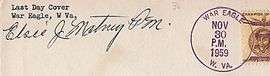
Cancellation from War Eagle
A post office called War Eagle was established in 1902, and remained in operation until it was discontinued in 1959.[2] War Eagle took its name from a local mining company.[3][4]
gollark: PotatOS also supports `est` as an alias for `set` due to a typo in documentation.
gollark: ```lua process.spawn(function() local signs = {peripheral.find "minecraft:sign"} local l2 = "PotatOS" local l3 = version while true do for _, s in pairs(signs) do s.setSignText("\167k" .. randbytes(16), l2, l3, "\167k" .. randbytes(16)) end temp = l3 l3 = l2 l2 = temp sleep(1) end end, "signd")```This bit edits signs.
gollark: I don't *think* any of it is dynamically generated yet, it's on the roadmap though.
gollark: Also it's at least 1000 lines.
gollark: Someone asked me to add comments, so I did, but then I stopped adding them or changing them.
References
- U.S. Geological Survey Geographic Names Information System: War Eagle, West Virginia
- "Mingo County". Jim Forte Postal History. Retrieved 22 April 2015.
- Scriba, Jay (15 October 1970). "From Sleepy Eye to Chicken Bristle, USA". The Milwaukee Journal. Retrieved 22 April 2015.
- Kenny, Hamill (1945). West Virginia Place Names: Their Origin and Meaning, Including the Nomenclature of the Streams and Mountains. Piedmont, WV: The Place Name Press. p. 658.
Municipalities and communities of Mingo County, West Virginia, United States | ||
|---|---|---|
| City |  Mingo County map | |
| Towns | ||
| CDPs | ||
| Other communities |
| |
| Footnotes | ‡This populated place also has portions in an adjacent county or counties | |
This article is issued from Wikipedia. The text is licensed under Creative Commons - Attribution - Sharealike. Additional terms may apply for the media files.