Wami Taksar
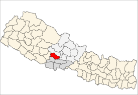
Wamitaksar (Nepali:वामीटक्सार) is a town and Village Development Committee in Gulmi District in the Lumbini Zone of central Nepal. At the time of the 1991 Nepal census it had a population of 6421.[1] It is located 128.54 kilometers of the capital of Nepal Kathmandu.
Wami Taksar वामीटक्सार Wamitaksar | |
|---|---|
Village Development Committee | |
 Wami Taksar Location in Nepal | |
| Coordinates: 28°11′N 83°18′E | |
| Country | |
| Zone | Lumbini Zone |
| District | Gulmi District |
| Elevation | 872 m (2,861 ft) |
| Population (1991) | |
| • Total | 6,421 |
| Time zone | UTC+5:45 (Nepal Time) |
Other
Climate
| Normal | Record | |
|---|---|---|
| High | 27° | 29° |
| Low | 17° | 21° |
Temples
- Bhimsen Temple
- Maikasthan
Point of interest
- Badighat - River in Wamitaksar
- Wamitaksar Bus Park - Bus Park
- Shree Mahendra Adarsh Higher Secondary School
Gallery
- Landscapes and Climates of Wamitaksar
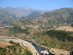 Badighat
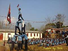 People holding Flag of Nepal
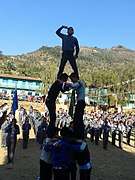 Salute to Mother Nepal
gollark: I mean, I certainly could.
gollark: Maybe you are to?
gollark: For purposes.
gollark: PHP string split.
gollark: So obviously it's mine, and you should guess as such.
References
- "Nepal Census 2001". Nepal's Village Development Committees. Digital Himalaya. Retrieved 15 September 2008.
External links
This article is issued from Wikipedia. The text is licensed under Creative Commons - Attribution - Sharealike. Additional terms may apply for the media files.