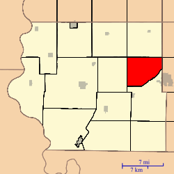
Walnut Township, Fremont County, Iowa
Walnut Township is one of thirteen townships in Fremont County, Iowa, United States. As of the 2010 census, its population was 145 and it contained 66 housing units.[1]
Walnut Township | |
|---|---|
 Location in Fremont County | |
| Coordinates: 40°46′59″N 95°26′56″W | |
| Country | United States |
| State | Iowa |
| County | Fremont |
| Area | |
| • Total | 25.2 sq mi (65.26 km2) |
| • Land | 25.2 sq mi (65.26 km2) |
| • Water | 0 sq mi (0 km2) 0% |
| Elevation | 1,109 ft (338 m) |
| Population (2010)[1] | |
| • Total | 145 |
| • Density | 5.8/sq mi (2.2/km2) |
| Time zone | UTC-6 (CST) |
| • Summer (DST) | UTC-5 (CDT) |
| ZIP codes | 51601, 51639 |
| GNIS feature ID | 0468884[2] |
Geography
As of the 2010 census, Walnut Township covered an area of 25.2 square miles (65 km2), all land.[1]
Transportation
School districts
- Farragut Community School District
- Shenandoah Community School District
Political districts
- Iowa's 3rd congressional district
- State House District 23
- State Senate District 12
gollark: Only 374mm.
gollark: It would be better than the palaiologistry of now.
gollark: * have the orbital cameras monitor all mail in existence.
gollark: I just hv
gollark: No you didn't.
References
- "TIGER/Line Shapefiles". United States Census Bureau.
- "2010 Census Gazetteer". United States Census Bureau. Retrieved 2014-02-23.
- "Walnut Township, Fremont County, Iowa". Geographic Names Information System. United States Geological Survey. Retrieved 2014-02-23.
External links
This article is issued from Wikipedia. The text is licensed under Creative Commons - Attribution - Sharealike. Additional terms may apply for the media files.