Wald, Baden-Württemberg
Wald is a municipality in the district of Sigmaringen in Baden-Württemberg in Germany.
| Coat of arms | District | Inhabitants (2010) | Size |
|---|---|---|---|
| Wald (main locality) | 843 | 827,47 ha | |
| Glashütte | 97 | 178,66 ha | |
| Hippetsweiler | 201 | 348,73 ha | |
| Kappel | 105 | 334,66 ha | |
| Reischach | 67 | 217,61 ha | |
| Riedetsweiler | 83 | 203,61 ha | |
| Rothenlachen | 38 | 217,26 ha | |
| Ruhestetten | 174 | 643,29 ha | |
| Sentenhart | 340 | 575,80 ha | |
| Walbertsweiler | 639 | 839,57 ha |

Well in the Wald monastery
Towns and municipalities in Sigmaringen | ||
|---|---|---|
Wald | |
|---|---|
_1.JPG) Wald monastery | |
_COA.svg.png) Coat of arms | |
Location of Wald within Sigmaringen district .png) | |
 Wald 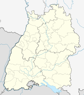 Wald | |
| Coordinates: 47°56′12″N 9°10′24″E | |
| Country | Germany |
| State | Baden-Württemberg |
| Admin. region | Tübingen |
| District | Sigmaringen |
| Government | |
| • Mayor | Werner Müller |
| Area | |
| • Total | 43.87 km2 (16.94 sq mi) |
| Elevation | 657 m (2,156 ft) |
| Population (2018-12-31)[1] | |
| • Total | 2,680 |
| • Density | 61/km2 (160/sq mi) |
| Time zone | CET/CEST (UTC+1/+2) |
| Postal codes | 88639 |
| Dialling codes | 07578 |
| Vehicle registration | SIG |
| Website | www.wald-hohenzollern.de |
References
- "Bevölkerung nach Nationalität und Geschlecht am 31. Dezember 2018". Statistisches Landesamt Baden-Württemberg (in German). July 2019.
| Authority control |
|---|
This article is issued from Wikipedia. The text is licensed under Creative Commons - Attribution - Sharealike. Additional terms may apply for the media files.