Waitomo
Waitomo is a rural community in the King Country region of New Zealand's North Island. It includes Waitomo Caves, a solutional cave system and popular tourist attraction. The two villages of Waitomo and Hangatiki serve visiting tourists.
Waitomo | |
|---|---|
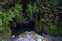 The entrance to a cave in the Waitomo area | |
 Waitomo | |
| Coordinates: | |
| Country | New Zealand |
| Region | Waikato Region |
| Territorial authority | Waitomo District |
| Time zone | UTC+12 (NZST) |
| • Summer (DST) | UTC+13 (NZDT) |
| Area code(s) | 07 |
The word Waitomo comes from the Māori language wai meaning water and tomo meaning a doline or sinkhole; it can thus be translated to be "water passing through a hole".[1] The caves are formed in Oligocene limestone.[2]
Waitomo Caves Hotel is located in the Waitomo township.
Waitomo Caves
History
The limestone landscape of the Waitomo District area has been the centre of increasingly popular commercial caving tourism from as early as 1900. Initially mostly consisting of impromptu trips guided by local Māori, large sections of cave near Waitomo Caves were later taken over by the Crown and managed as a (relatively genteel) tourism attraction from 1904 onwards.[3] A 1915 guide said, "It is reached by railway to Hangatiki, thence 6 miles by coach along a good road".[4]
Today, a number of companies, large and small, specialise in leading tourists through the caves of the area, from easily accessible areas with hundreds of tourists per hour in the peak season, to extreme sports, like crawls into cave systems which are only seen by a few tourists each day. A visit to Waitomo Caves made number 14 amongst a list of 101 "Kiwi must-do's" in a New Zealand Automobile Association poll of over 20,000 motorists published 2007,[5] and in 2004, around 400,000 visitors entered caves in the area.[3]
Main caves
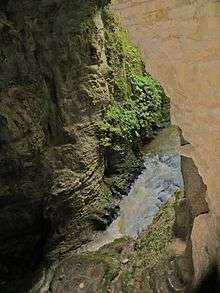
The main caves in the area are the Waitomo Glowworm Caves, Ruakuri Cave, Aranui Cave, and Gardner's Gut.[6] They are noted for their stalactite and stalagmite displays, and for the presence of glowworms (the fungus gnat Arachnocampa luminosa).[7]
The Waitomo Caves were seen in Episode 4 "Caves" of BBC's Planet Earth.
Walkways
The Waitomo Walkway runs through the valley of the Waitomo Stream (a tributary of the Waipa River) for 3.3 km (2.1 mi) from the village to Ruakuri Scenic Reserve.[8] At the reserve the Ruakuri Walk leads through short caves to the Ruakuri Natural Bridge.[9]
Te Araroa, a national long distance walkway, passes through Waitomo. The section from Mt Pirongia joins the Waitomo Walkway to enter the village.[10] The 17.5 km (10.9 mi) section to Te Kuiti goes over Mangapu River suspension bridge and through Pehitawa kahikatea forest.[11]
Marae
The community has a number of marae, affiliated with Maniapoto hapū:[12][13]
- Kaputuhi Marae is affiliated with the hapū of Matakore, Pare te Kawa, Peehi and Rōrā.
- Te Kauae Marae and Te Kauae o Niu Tereni meeting house are affiliated with the hapū of Huiao, Kinohaku, Peehi and Te Kanawa.
- Te Korapatu Marae is affiliated with the hapū of Peehi and Te Kanawa.
- Pohatuiri Marae is affiliated with the hapū of Uekaha.
- Tokikapu Marae and Matua a Iwi meeting house are affiliated with the hapū of Ruapuha, Te Kanawa and Uekaha.[14]
Education
Waitomo Caves School is a co-educational state primary school,[15][16] with a roll of 28 as of March 2020.[17][18]
References
- "Waitomo Caves". Encyclopedia of New Zealand (1966).
- "The Geological History of New Zealand". Retrieved 16 May 2014.
- Caving tourism (from Te Ara: The Encyclopedia of New Zealand)
- Bradbury, E E (1915). The Raglan and Kawhia Districts. Waikato University library: Bradbury. p. 85.
- Dye, Stuart (10 February 2007). "Peaks, sounds, parks and islands tops in Kiwi eyes". The New Zealand Herald. Retrieved 1 December 2011.
- "Ruakuri Caves Tour – Waitomo New Zealand". www.waitomo.com.
- Glowworm Caves, Waitomo (from the Waitomo Caves information website 'waitomo-caves.com')
- "Waitomo Walkway". www.doc.govt.nz. Department of Conservation. Retrieved 4 February 2017.
- "Ruakuri Walk". www.doc.govt.nz. Department of Conservation. Retrieved 4 February 2017.
- "Pirongia to Waitomo:Te Araroa – New Zealand's Trail – Waikato / King Country". www.teararoa.org.nz. Retrieved 4 February 2017.
- "Pehitawa Track:Te Araroa – New Zealand's Trail – Waikato / King Country". www.teararoa.org.nz. Retrieved 4 February 2017.
- "Te Kāhui Māngai directory". tkm.govt.nz. Te Puni Kōkiri.
- "Māori Maps". maorimaps.com. Te Potiki National Trust.
- "Tainui Maniapoto - Hapū and Marae". Te Puni Kōkiri. Retrieved 9 December 2019.
- "Waitomo Caves School Official School Website". waitomocaves.school.nz.
- "Waitomo Caves School Ministry of Education School Profile". educationcounts.govt.nz. Ministry of Education.
- "New Zealand Schools Directory". New Zealand Ministry of Education. Retrieved 26 April 2020.
- "Waitomo Caves School Education Review Office Report". ero.govt.nz. Education Review Office.