Wahlsten, Minnesota
Wahlsten is an unincorporated community in Kugler Township, Saint Louis County, Minnesota, United States.
Wahlsten | |
|---|---|
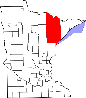
 Wahlsten Location of the community of Wahlsten within Kugler Township, Saint Louis County  Wahlsten Wahlsten (the United States) | |
| Coordinates: 47°44′09″N 92°17′01″W | |
| Country | United States |
| State | Minnesota |
| County | Saint Louis |
| Township | Kugler Township |
| Elevation | 1,470 ft (450 m) |
| Population | |
| • Total | 10 |
| Time zone | UTC-6 (Central (CST)) |
| • Summer (DST) | UTC-5 (CDT) |
| ZIP codes | 55790 or 55732 |
| Area code(s) | 218 |
| GNIS feature ID | 662729[1] |
Geography
The community is located 5 miles south of Tower at the intersection of State Highway 135 (MN 135) and Saint Louis County Road 26 (Wahlsten Road). Wahlsten is located 17 miles north of Aurora. State Highway 169 (MN 169) and the Pike River are nearby. The community of Embarrass is also in the area.
History
The community was named for August Wahlsten, a Swedish settler.[2]
gollark: -p https://radio-ic.osmarks.net/128k.ogg
gollark: Chromatic aberration induced by the gay field is well-documented and is in fact the operating principle of gaydar.
gollark: ↑
gollark: As I've said before, I don't think it was ever that.
gollark: We can only measure it from consumer preferences, and (since people would lie if you directly *asked* about their willingness to pay for various things for various reasons), short of orbital mind-reading lasers, the only useful way to do this is observing markets.
References
- "Wahlsten, Minnesota". Geographic Names Information System. United States Geological Survey.
- Upham, Warren (1920). Minnesota Geographic Names: Their Origin and Historic Significance. Minnesota Historical Society. p. 491.
- Official State of Minnesota Highway Map – 2011/2012 edition
This article is issued from Wikipedia. The text is licensed under Creative Commons - Attribution - Sharealike. Additional terms may apply for the media files.