Vlasina (river)
The Vlasina (Serbian Cyrillic: Власина), is a river in southeastern Serbia, a 70 km-long[1] outflow of the Vlasina Lake and a right tributary to the Južna Morava, which also gives its name to the surrounding Vlasina region.
| Vlasina (Власина) | |
|---|---|
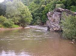 River Vlasina, location: Pukli kamen | |
| Location | |
| Country | Serbia |
| Physical characteristics | |
| Source | |
| • location | Vlasina Lake, southeastern Serbia |
| • elevation | 1,213 m (3,980 ft) |
| Mouth | |
• location | Južna Morava, east of Leskovac, Serbia |
• coordinates | 42°59′54″N 22°01′44″E |
| Length | 70 km (43 mi)[1] |
| Basin size | 991 km2 (383 sq mi)[2] |
| Discharge | |
| • average | 11 m3/s (390 cu ft/s) |
| Basin features | |
| Progression | South Morava→ Great Morava→ Danube→ Black Sea |
Characteristics
The Vlasina flows out from the Vlasina Lake at an altitude of 1,213 m. Lake used to be a large, muddy peat bog, but in 1947-51 the Vlasina was dammed by the long, earth dam and the bog was turned into an artificial lake. The river flows to the north, between the mountains of Čemernik on the west, and Gramada on the east. It flows through Crna Trava, regional and municipal center, and the villages of Brod, Krstićevo and Jabukovik, where it reaches the Lužnica mountain and receives the Gradska reka from the right.
The river bends to the west, along the southern slopes of Lužnica, and receives from the right the Tegošnica (at Donje Gare village) and the Lužnica (at Svođe). As the Vlasina continues on the southernmost slopes of the Suva Planina and Babička Gora mountains, it reaches the town of Vlasotince and western parts of the low Leskovac field, part of the composite valley of the Južna Morava. After the villages of Batulovce and Stajkovce, the Vlasina empties into the Južna Morava, east of the Leskovac's eastern suburb of Mrštane.
There is a small dam in Vlasotince, close to downtown, with a reservoir and the beach.[3]
The Vlasina drains an area of 991 km²,[2] belongs to the Black Sea drainage basin and it is not navigable.
Floods
Usually a calm river, Vlasina is infamous for catastrophic, torrential flooding, especially of Vlasotince. The town was flooded in 1948.[4]
On 26 June 1988, after a period of heavy rains, Vlasina valley was a site of catastrophic floods. Extreme downpours and heavy storms affected river's watershed area in the municipalities of Vlasotince, Crna Trava, Babušnica, Pirot and Leskovac. Upper and central watershed sections received 100 to 200 l/m2 (2.0 to 4.1 imp gal/sq ft) with an absolute peak in Rakov Dol, with 220 l/m2 (4.5 imp gal/sq ft). This was absolute daily maximum in the entire Serbia. Instead of an average discharge of 11 m3/s (390 cu ft/s), the Vlasina swelled 145 times, to 1,600 m3/s (57,000 cu ft/s). Tidal wave was 9 m (30 ft) tall and, to make things worst, smashed the town during the night. Both the discharge and the height of the wave were never recorded previously.[4]
Military was dispatched to help the residents. In Vlasotince, 1,700 buildings were flooded, 120 were completely destroyed, so as 55 artisan shops, while all major companies and economic organizations were disabled. Numerous streets were washed away, so as 17 bridges along the river, town's bus station, power station and all generators, sports fields, post offices, city waterworks, overhead power lines and Vlasotince's famous "Park" garden. The Vlasotince-Crna Trava trunk road was cut off on 36 locations. Apart from Vlastince, huge damage stroke the villages of Dobroviš, Tegošnica, Gornji Orah, Svođe, Dejan, Kruševica, Boljare, Manastirište, Konopnica and Stajkovce. All crops were destroyed and the livestock population was decimated.[4]
In total, the area affected by the catastrophe covered more than 1,000 km2 (390 sq mi), and caused a damage of around US$1 billion (or 355 billion of current Yugoslav dinars), despite the river flow being supposedly regulated. Subsequent analysis showed a number of flaws in the design of the protected catchment. In the next period, a solidarity settlement was built in Vlasotince and new bridges were constructed in the villages Manastirište, Tegošnica, Stajkovac, Ravni Dol and Donji Dejan. A book commemorating the event, Događaj za zaborav i nezaborav (Event for oblivion and remembrance) was published by Dragoljub Stanojević.[4]
The Vlasina again flooded its valley in 2008.[4]
See also
| Wikimedia Commons has media related to Vlasina. |
References
- Statistical Yearbook of the Republic of Serbia 2017 (PDF) (in Serbian and English). Belgrade: Statistical Office of the Republic of Serbia. October 2017. p. 16. ISSN 0354-4206. Retrieved 30 May 2018.
- Velika Morava River Basin, ICPDR, November 2009, p. 2
- Danilo Kocić (2 August 2020). = Језеро између вируса и врућине [Lake between the virus and the heat]. Politika (in Serbian).
- Danilo Kocić (28 June 2020). Највеће ћуди мирне реке Власине [Major whims of timid Vlasina river]. Politika (in Serbian). pp. 12–13.
Sources
- Mala Prosvetina Enciklopedija, Third edition (1985); Prosveta; ISBN 86-07-00001-2
- Jovan Đ. Marković (1990): Enciklopedijski geografski leksikon Jugoslavije; Svjetlost-Sarajevo; ISBN 86-01-02651-6
- Gavrilovic, Zoran; Matovic, Zivorad (January 1991). Armanini, Aronne; Silvio, Giampaolo (eds.). "Review of disastrous torrent flood on the vlasina river on June 26, 1988". Lecture Notes in Earth Sciences, Berlin Springer Verlag. 37: 235–250. Bibcode:1991LNES...37..235G. doi:10.1007/BFb0011177.