Virginia State Route 62
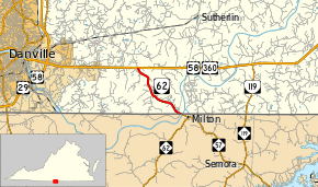
State Route 62 (SR 62) is a primary state highway in the U.S. state of Virginia. Known as Milton Highway, the state highway runs 4.01 miles (6.45 km) from the North Carolina state line, where North Carolina Highway 62 (NC 62) continues into Milton, north to U.S. Route 58 and US 360 east of Danville. SR 62 was assigned as a number upgrade of SR 726 to connect US 58 with NC 62 in 1946.
| ||||
|---|---|---|---|---|
| Milton Highway | ||||
 | ||||
| Route information | ||||
| Maintained by VDOT | ||||
| Length | 4.01 mi[1] (6.45 km) | |||
| Existed | 1946–present | |||
| Major junctions | ||||
| South end | ||||
| North end | ||||
| Location | ||||
| Counties | Halifax, Pittsylvania | |||
| Highway system | ||||
| ||||
Route description
_between_River_Bend_Road_(Virginia_State_Secondary_Route_1527)_and_Sonshine_Drive_in_southeastern_Pittsylvania_County%2C_Virginia.jpg)
SR 62 begins at the North Carolina state line in the extreme southwestern corner of Halifax County. The roadway continues southeast as NC 62, which immediately crosses the Dan River into the town of Milton, where NC 62 turns south toward Burlington at its intersection with NC 57. Milton is just south of Virginia International Raceway, which lies on the east side of the Dan River. SR 62 almost immediately enters southeastern Pittsylvania County and remains in the county for the remainder of the route. It heads northwest through farmland to an intersection with US 58 and US 360 (Philpott Road) about 8 miles (13 km) east of downtown Danville. The roadway continues north as SR 726 (Ringgold Depot Road), which heads northwest toward Ringgold Depot.[1][2]
History
In the 1930s, present SR 62 was designated as part of State Route 726.[3] SR 62 was transferred to the primary state highway system in 1946, connecting with North Carolina Highway 62 towards Roxboro and Oxford, North Carolina.[4] The State Route 62 designation was already in use on a route in western Virginia; that route was renumbered to State Route 78.
Major intersections
| County | Location | mi[1] | km | Destinations | Notes |
|---|---|---|---|---|---|
| Halifax | | 0.00 | 0.00 | North Carolina state line | |
| Pittsylvania | | 4.01 | 6.45 | ||
| 1.000 mi = 1.609 km; 1.000 km = 0.621 mi | |||||
References
- "Daily Traffic Volume Estimates Jurisdiction Report: Pittsylvania County" (PDF). Virginia Department of Transportation. 2009. Retrieved 2011-07-29.
- Google (2011-07-29). "Virginia State Route 62" (Map). Google Maps. Google. Retrieved 2011-07-29.
- Map of Pittsylvania County, revised July 1, 1936
- State Highway Commission of Virginia (May 2–3, 1946). Minutes of Meeting (PDF) (Report). Roanoke, VA: Commonwealth of Virginia. p. 5.
External links
| Wikimedia Commons has media related to Virginia State Route 62. |
