Villahermosa del Campo
Villahermosa del Campo is a municipality located at the feet of the Sierra de Cucalón, in the province of Teruel, Aragon, Spain. According to the 2004 census (INE), the municipality has a population of 97 inhabitants.
Villahermosa del Campo | |
|---|---|
 Flag  Seal | |
 Villahermosa del Campo | |
| Coordinates: 41°07′N 1°15′W | |
| Country | Spain |
| Autonomous community | Aragon |
| Province | Teruel |
| Comarca | Jiloca |
| Area | |
| • Total | 19.20 km2 (7.41 sq mi) |
| Elevation | 956 m (3,136 ft) |
| Population (2018)[1] | |
| • Total | 94 |
| • Density | 4.9/km2 (13/sq mi) |
| Time zone | UTC+1 (CET) |
| • Summer (DST) | UTC+2 (CEST) |
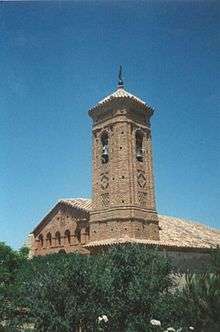
Belltower of the 15th century Santa María Magdalena church in Villahermosa
There are ruins of ancient Iberian settlements located within Villahermosa's municipal term. These are known as Castillo de Nogueras and Castillo de Santa Catalina.[2]
It is located at the western end of the Sierra de Cucalón area.
See also
- Jiloca Comarca
- List of municipalities in Zaragoza
References
- Municipal Register of Spain 2018. National Statistics Institute.
- GEA - Huerva, valle de la
External links
| Wikimedia Commons has media related to Villahermosa del Campo. |
This article is issued from Wikipedia. The text is licensed under Creative Commons - Attribution - Sharealike. Additional terms may apply for the media files.