Veresegyház
Veresegyház | |
|---|---|
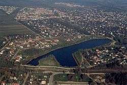 Aerial view | |
 Flag  Coat of arms | |
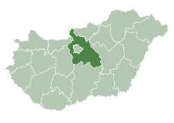
 Veresegyház Location of Veresegyház | |
| Coordinates: 47.65046°N 19.28299°E | |
| Country | |
| County | Pest |
| Government | |
| • Mayor | Béla Pásztor (independent) |
| Area | |
| • Total | 28.56 km2 (11.03 sq mi) |
| Population (2017) | |
| • Total | 18,122[1] |
| Time zone | UTC+1 (CET) |
| • Summer (DST) | UTC+2 (CEST) |
| Postal code | 2112 |
| Area code(s) | 28 |
Veresegyház is a town in Pest county, Hungary.
Location
This village first appeared as Vesereghatz in maps made by Hungarian clerk Lazarus Secretarius between 1510 and 1520. The town lies in the Gödöllő-Hills near Cserhát. The nearest neighbour is Szada.
Attractions
- Roman Catholic Church: Built in 1777 by Christoph Anton Migazzi in the style of Louis XVI.
- The parish buildings and monuments from the lake not far from the stone crosses, there are pedestals to Mary Magdalene and St. John the Evangelist.
- Roman Catholic cemetery: in 1806 and 1849 with red marble headstones
- Reformed Church: was built in 1786.
- Bear and wolf shelters: On November 24, 1998 Central Europe's only bear shelter was opened, covering 3.5 acres (1.4 ha). There are wolves in the park as well.
Twin towns — sister cities
Veresegyház is twinned with:


Notable residents
- Zoltán Bánföldi, former Hungarian footballer
- József Darányi, Hungarian athlete
- Zoltán Joó, Hungarian painter
- Zoltán Téglás, American-born Hungarian singer, songwriter and producer
- István Sipeki, footballer
- Norbert Palásthy, footballer
- István Kövesfalvi, footballer
- Zoltán Bánföldi, footballer
Resources
- Lajos Horváth: Veresegyház. Local history and village plans. Veresegyház, 1977. 251 p.
gollark: =tex 1 - (1 - \frac{P_{covid}}{P})^{N_{gathering}}
gollark: Couldn't this just be done as `1 - ((1 - positives/population) ^ gathering)`?
gollark: Christ is his own antiparticle, so originally just Christ, not sure about the remaining one.
gollark: I would be impressed if they managed to get tracking beacons with reasonable range and battery life to actually fit.
gollark: Yes, it's not really a *significant* issue compared to the bigger ones of spreading disease, but it is there.
External links
- Street map (in Hungarian)
- Documentary film about the city (in Hungarian)
- Veresegyház Official Website
- Facebook page
- Website of the Roman Catholic Church
- Photos of Veresegyház
References

This article is issued from Wikipedia. The text is licensed under Creative Commons - Attribution - Sharealike. Additional terms may apply for the media files.