Veinticinco de Mayo, Uruguay
Veinticinco de Mayo 25 de Mayo | |
|---|---|
Town | |
 Veinticinco de Mayo Location in Uruguay | |
| Coordinates: 34°11′23″S 56°20′24″W | |
| Country | |
| Department | Florida Department |
| Population (2011) | |
| • Total | 1,852 |
| Time zone | UTC -3 |
| Postal code | 94005 |
| Dial plan | +598 4339 (+4 digits) |
Location
The town is located on Route 76, 6 kilometres (3.7 mi) east of its intersection with Route 77. The railroad track Montevideo - Florida passes through the village. The stream Arroyo Isla Mala, tributary of Arroyo Santa Lucía Chico, flows along the west and north limits of the village, forming a lake or wetland to the east side of it.
History
Its original name was "Isla Mala" and it was recognized as a recently created populated centre by a decree of 1 September 1875. It was renamed to its present name and declared a "Pueblo" (village) on 17 July 1918 by the Act of Ley N° 6.196.[1] Its status was elevated to "Villa" (town) on 28 January 1985 by the Act of Ley N° 15.706.[2]
Population
In 2011, Veinticinco de Mayo had a population of 1,852.[3]
| Year | Population |
|---|---|
| 1908 | 4,884 |
| 1963 | 1,692 |
| 1975 | 1,874 |
| 1985 | 1,834 |
| 1996 | 1,931 |
| 2004 | 1,845 |
| 2011 | 1,852 |
Source: Instituto Nacional de Estadística de Uruguay[1]
Places of worship
- Immaculate Conception Parish Church (Roman Catholic)
References
- "Statistics of urban localities (1908–2004)" (PDF). INE. 2012. Retrieved 4 September 2012.
- "Ley Nº 15.706". República Oriental del Uruguay, Poder Legislativo. 1985. Archived from the original on 10 April 2013. Retrieved 4 September 2012.
- "Censos 2011 Cuadros Florida". INE. 2012. Archived from the original on 23 November 2012. Retrieved 25 August 2012.
External links
Capital: Florida | ||
| Towns and villages | 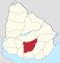 | |
| Sights | ||