Varenne (river)
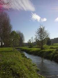
The Varenne is a river of Normandy, France, 40 kilometres (25 mi) in length, flowing through the department of Seine-Maritime and it is a tributary of the Arques River.[1]
| Varenne | |
|---|---|
 | |
| Location | |
| Country | France |
| Physical characteristics | |
| Source | |
| • location | Montérolier |
| Mouth | |
• location | Arques River |
• coordinates | 49°53′30″N 1°7′50″E |
| Length | 40 km (25 mi) |
| Basin size | 345 km2 (133 sq mi) |
| Discharge | |
| • average | 3.5 m3/s (120 cu ft/s) |
| Basin features | |
| Progression | Arques→ English Channel |
Geography
The river's source is just northwest of Buchy near to Montérolier, Its valley separates the pays de Caux on the west bank from the pays de Bray to the east.
Of the three rivers that form the Arques, the Varenne is the shortest but paradoxically has the largest catchment area and highest speed (3.5 m/s). The only significant tributary is the Herring Creek (8 km in length) which joins on the left bank at Rosay.
Its course takes it past the communes of Saint-Martin-Osmonville, Saint-Saëns, through the forest of Eawy and on to Bellencombre, Saint-Hellier, Torcy-le-Grand, Torcy-le-Petit, Martigny, and finally Arques-la-Bataille where it joins the Eaulne and the Béthune Rivers to form the Arques River.
Like other rivers in the region, the Varenne is classified as a first class river, offering anglers the chance to catch salmon and trout. The river is also used near its source, to supply the drinking water system.
See also
External links
- The Varenne on the Sandre website (in French)
- Accès aux villes et villages de France du Quid (in French)
- French Geography website (in French)
Notes
- This article is based on the equivalent article from the French Wikipedia, consulted on October 14, 2008.