Valença, Rio de Janeiro
Valença (Portuguese pronunciation: [vaˈlẽsɐ]) is a municipality located in the Brazilian state of Rio de Janeiro. Its population was estimated at 73,445 in 2014 and its area is 1,305 square kilometres (504 sq mi).[1] The city is the seat of the Roman Catholic Diocese of Valença.
Valença | |
|---|---|
Municipality | |
| Município de Valença | |
.png) Flag  Seal | |
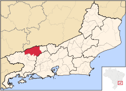 Location of Valença in the state of Rio de Janeiro | |
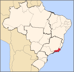
 Valença Location of Valença in Brazil | |
| Coordinates: 22°14′45″S 43°42′00″W | |
| Country | |
| Region | Southeast |
| State | |
| Government | |
| • Prefeito | Fernando Graça (PP) |
| Area | |
| • Total | 1,304.813 km2 (503.791 sq mi) |
| Elevation | 560 m (1,840 ft) |
| Population (2010) | |
| • Total | 71,843 |
| Time zone | UTC-3 (UTC-3) |
| Website | |
Valença has five districts: Conservatória ("City of Serenades"), Barão de Juparanã ("City of the Barons), Parapeúna, Santa Isabel do Rio Preto and Pentagna. Today its economy is geared especially for agriculture and the existing university center in the municipal headquarters.
The municipality contains part of the 5,952 hectares (14,710 acres) Serra da Concórdia State Park, created in 2002.[2]
People
- Clementina de Jesus; (1901-1987), samba singer
gollark: Which reminds me, maybe I ought to add a long polling mode.
gollark: If I had done that, would I say so instead of merely basking in the knowledge that those devices were, hypothetically, part of the PotatOS Computing Network™ and able to do arbitrary computation/networking tasks as required (via SPUDNET)?
gollark: But yes, I totally didn't* remotely install potatOS in place of the firmware on all your network accessible devices.
gollark: Oh yes, SPUDNET-py.
gollark: What are you actually doing?
References
- IBGE -
- Parque Estadual da Serra da Concórdia (in Portuguese), Inea: Instituto Estadual do Ambiente, retrieved 2017-01-18
Capital: Rio de Janeiro | |||||||||||
| Mesoregion Baixadas |
|  | |||||||||
| Mesoregion Centro Fluminense |
| ||||||||||
| Mesoregion Metropolitana do Rio de Janeiro |
| ||||||||||
| Mesoregion Noroeste Fluminense |
| ||||||||||
| Mesoregion Norte Fluminense |
| ||||||||||
| Mesoregion Sul Fluminense |
| ||||||||||
This article is issued from Wikipedia. The text is licensed under Creative Commons - Attribution - Sharealike. Additional terms may apply for the media files.