Val Verde Basin
The Val Verde Basin is a marginal foreland basin located between West Texas and southeastern New Mexico, just southeast of the Midland Basin. The Val Verde is a sub-basin of the larger Permian Basin and is roughly 24–40 km wide by 240 km long.[1] It is an unconventional system and its sediments were deposited during a long period of flooding during the Middle to Late Cretaceous. This flooding event is referred to as the Western Interior Seaway, and many basins in the Western United States can attribute their oil and gas producing basins to carbonate deposition during this time period.
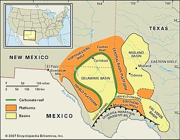
The Val Verde's structural architecture devolved mainly during the Early Carboniferous to Late Permian period during the Ouachita orogeny. This produced minor structural folding throughout the basin. Today, the Val Verde Basin is a major gas producing system and has recently been recognized for harboring over 5 tcf (trillion cubic feet) of natural gas.[2]
Origin and evolution
The formation of the western interior seaway during the mid to late Cretaceous caused widespread carbonate deposition throughout most of the western United States. During this time period, the seaway flooded the North American mainland and divided the Eastern and Western portions of North America for roughly 60 million years.
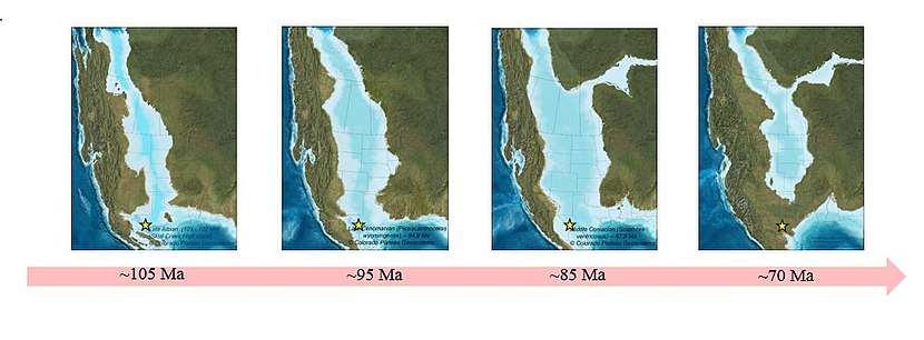
- ~ 105 Ma: Shallow, low energy environment
- ~ 95 Ma: Period of transgression, moderate - deep water deposits
- ~ 85 Ma: Continued transgression, moderate - deep water deposits
- ~ 70 Ma: Retreat of the Western Interior Seaway
Throughout this time period, marine fauna flourished in the warm, shallow water conditions. This led to widespread carbonate deposition throughout the region.[3] Today, many basins throughout the region attribute their source rock and reservoir rock to the sedimentary deposits created during this time. As the seaway transgressed and regressed over time, alternating layers of sandstone and shale were deposited, depending on the depth and overall energy of the environment. This is when the modern-day reservoir rock of the Val Verde basin, the Ozona sequence, was deposited.
The structure of the Val Verde Basin formed as result of tectonic influences for the last ~100 million years.
Major tectonic influences
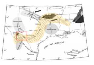
Syndepositional tectonic events produced the stratigraphic architecture, sandstone distribution and the lithofacies developments within the Val Verde. Although the basin is unconventional, sequence boundaries are marked by systematic shifting of sandstone depocenters in response to episodic thrusting events over time.
Ouachita orogeny:~318-271 Ma
As plate convergence from the Ouachita orogeny began and progressed from the north to the south, offlap and onlap stratigraphic geometries were produced. The orogeny contributed a large amount of sediments from clastic rocks. These were deposited as thick, subaqueous deltaic systems which gradually filled the modern day midland basin over time.[4] The Ouachita Orogeny thrust belt caused regional compression which led to overthrust structures, faulting and folding throughout the region.[5]

Laramide orogeny:~70-80 Ma
The Laramide orogeny was a major tectonic event that caused the most recent and significant deformation in the United States. The Subduction of the Farallon Plate beneath the North American Plate produced compression all across the western portion of the US.[6] Crustal deformation occurred inland from the plate margin and it is mostly related to the deformation of northwestern United States. However this, in combination with Cenozoic rifting produced from the San Andreas fault, crustal folding, faulting and overall deformation have affected the southern regions of the continental US.[7]
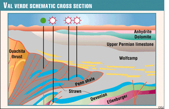
Generalized cross section
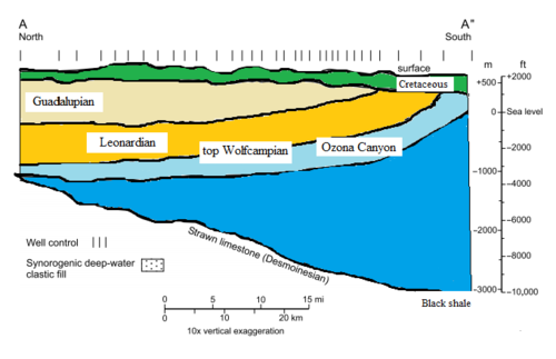
Ozona sequence
The Ozona formation is part of the larger, unconventional Canyon sandstone system, a tight gas play within the Val Verde basin.[2] Tight reservoirs such as this are characterized by low permeability and low porosity, however the basin is still gas saturated and currently producing today.
Characteristics of the Ozona lithofacies
A description of the lithofacies of the Ozona sequence:[2]
| Lithofacies | Lithology | Bed thickness | Sedimentary Structures | Accessories | Depositional mechanism |
|---|---|---|---|---|---|
| Thick-bedded turbidites | Fine to coarse sandstone, minor mudstone | Sandstone
1–10 ft |
Sole marks, fluid escape, grading horizontal lamination | Mud clasts, organic debris, carbonate clasts | Intermediate-density turbidity currents |
| Thin-bedded turbidites | Fine to very fine sandstone, mudstone | Sandstone, mudstone
<1.0 ft |
Sole marks, horizontal and ripple lamination | Organic debris, burrows | Low-density turbidity currents |
| Mudstone | Mudstone, claystone | Variable | Horizontal lamination | Disseminated organic debris, burrows | Low-density turbidity currents, hemipelagic settling |
| Conglomeratic mudstone | Gravelly, sandy mudstone | Deformed bedding, unbedded | Floating clasts, soft-sediment deformation | Carbonate clasts, organic debris | Cohesive slumps, debris flow |
- The Ozona is composed of 4 main lithofacies: thick-bedded turbidites, thin-bedded turbidites, mudstone and conglomeratic mudstone
- Thick and thinnly bedded sandstones resemble deposits of mixed sandy and tubidity currents. In the Ozona sequence, the standard Bouma sequence of sedimentary structures properly characterizes the think and thinly bedded turbidites seen here.[8]
- Some channel-based erosion may occur locally which deposited sediments along with the turbidite deposits
Characteristics of the Ozona genetic facies
A description of the genetic facies of the Ozona sequence:[2]
| Genetic facies | Primary lithofacies | Sandstone bed, vertical trends | Lateral continuities |
|---|---|---|---|
| Turbidite channel | Think-bedded turbidites | Upward thinning, uniformly thick | Discontinuous local continuity between channel and levee |
| Turbidite lobe | Thick- and think-bedded turbidites | Upward thinning, upward thickickening, uniformly thick | Continuous across lobe |
| Channel levee | Thin bedded turbidites | No trend | Similar to turbidite channel |
| Muddy turbidite sheet | Thin bedded turbidites, mudstone | No trend | Think-bed continuity (>16 km) |
| Hemipelagic drape | Mudstone | Not applicable | Thin bedded continuity (>16 km) |
| Mass transport complex | Conglomeratic mudstone | No trend | Highly discontinuous |
Discontinuous beds are a relatively poor reservoir characteristic
- The hydrocarbon bearing lithologies are non-continuous. Instead they "pinch out" to form laterally discontinuous beds
- Pinching out sequences found throughout the basin:
- Turbidite Channel, Turbedite lobe
- Prograding Slope Channel and basin-floor Submarine Fan systems
- Turbidite lobe genetic facies are primarily sandstone dominated, although they are variable in their bedding sizes and styles.
Strawn formation
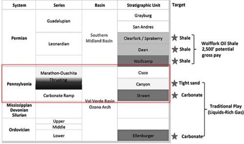
The Strawn formation is one of the more enigmatic hydrocarbon producing formations on the Eastern Shelf of the Midland Basin. It includes thick and thinly bedded sandstone units that are highly fossiliferous and reflects widespread carbonate deposition. Deposition was followed by "downwarping" and subsidence of the Midland Basin. The lower section of the formation is characterized by carbonate and siliciclastic deposits from 225 to 275 ft. in thickness. In some areas, thickness can reach up to 900 ft.[9] However, the formation is known to thin out towards the west-southwest.[10]
Depositional systems
The primary depositional systems within the Ozona are along deep-water slopes and basin-floor geomorphic settings. The deep water slopes drive the formation of turbidity deposits while the turbidite lobes form as a result of sediment deposition over time along the basin-floor. The thickness of these deposits is variable throughout the basin, but it is the thickest in the southwestern portion of the basin, following a northeast trend.[2]
Basin production
Despite the Val Verde's tight gas plays and relatively poor reservoir quality, it is still producing today. The Canyon Sandstone has produced more that 3.5 trillion cubic feet of gas.[2] The most recent reports from the U.S Geological Survey in 2016 indicates that the basin is capable of producing a total of 5 trillion cubic feet. Roughly 40% of the total gas production is generated from the Ozona field.
The Verde has three gas structures: the Puckett, Grey Ranch and Brown Bassett fields, which were discovered in the 1950s and 1960s. In total, these three gas fields have produced ~13 trillion cubic feet of gas so far, and are projected to produce a total of ~20 trillion cubic feet from deep (~14,000 ft deep) Ordovician carbonates.
References
- Montgomery, Scott L. (1996). "Val Verde Basin: Thrusted Strawn (Pennsylvanian) Carbonate Reservoirs, Pakenham Field Area" (PDF). AAPG Bulletin. 80 (7). ISSN 0149-1423.
- Hamlin, H. Scott (2009). "Ozona sandstone, Val Verde Basin, Texas: Synorogenic stratigraphy and depositional history in a Permian foredeep basin" (PDF). AAPG Bulletin. 93 (5): 573–594. doi:10.1306/01200908121. ISSN 0149-1423.
- Swift, J. T. Parrish, G. C. Gaynor, D. J. P. (1984). "Circulation in the Cretaceous Western Interior Seaway of North America, a Review". Cite journal requires
|journal=(help) - "Permian Basin | area, Texas, United States". Encyclopedia Britannica. Retrieved 2017-11-30.
- G., Elam, Jack (1972-01-01). "Tectonic Evolution of the Delaware-Val Verde Basin, Texas and New Mexico". doi:10.2118/3921-MS. Cite journal requires
|journal=(help) - "Laramide/Yellowstone". geoscience.wisc.edu. Retrieved 2017-12-04.
- "The Laramide Orogeny & the Tectonic Story of the Trans-Pecos". KRTS 93.5 FM Marfa Public Radio. Retrieved 2017-12-04.
- Bouma, Arnold H.; Ravenne, Christian (2004-01-01). "The Bouma Sequence (1962) and the resurgence of geological interest in the French Maritime Alps (1980s): the influence of the Grès d'Annot in developing ideas of turbidite systems". Geological Society, London, Special Publications. 221 (1): 27–38. doi:10.1144/GSL.SP.2004.221.01.03. ISSN 0305-8719.
- Wright, Wayne. "Depositional History of the Desmoinesian Succession (Middle Pennsylvanian) in the Permian Basin" (PDF). Bureau of Economic Geology.
- Hoye Eargle, D. (1960). "Stratigraphy of Pennsylvanian and Lower Permian Rocks in Brown and Coleman Counties, Texas" (PDF). Bureau of Economic Geology.