Utah State Route 167
State Route 167 (SR-167) is a north–south state highway Morgan and Weber counties in Utah, United States that connects Weber Canyon at I-84 in Mountain Green with the Ogden Valley near Huntsville over a span of 11 miles (18 km).
| ||||
|---|---|---|---|---|
| Trappers Loop Road | ||||
| Route information | ||||
| Defined by Utah Code §72-4-122 | ||||
| Maintained by UDOT | ||||
| Length | 11.09 mi[1] (17.85 km) | |||
| Existed | 1985, realigned in 1987[2]–present | |||
| Major junctions | ||||
| South end | ||||
| North end | ||||
| Highway system | ||||
| ||||
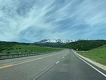
Nearly the entire route comprises Trappers Loop Road.
Route description

The route begins at the interchange with I-84 just west of Mountain Green in Morgan County, and travels east for about 1.5 miles (2.4 km), roughly parallel to I-84. At this point, the route makes a turn to the north, becoming Trappers Loop Road, which begins to climb into the mountains separating Weber Canyon and the Ogden Valley.
After climbing for 5.5 miles (8.9 km) and peaking at 6,000 feet (1,800 m) in elevation, the route crosses into Weber County and passes SR-226, the primary access road for Snowbasin ski resort. From here, the route winds its way back downhill, to the north, making its way towards the Ogden Valley area. Just before the route enters the valley near Huntsville, it exits the Uinta-Wasatch-Cache National Forest (the entire southern portion of the route lies in the national forest). The route then terminates at the intersection with SR-39, just south of Pineview Reservoir.[3]
History
The old Trappers Loop Road from the former Utah State Route 5 in Mountain Green to SR-39 near Huntsville was designated State Route 85 in 1935, and decommissioned in 1945. SR-167 was created in 1985 along the same road, from I-84 near Mountain Green to SR-39 south of Huntsville. At the same time, the Utah State Legislature allocated funding for the Utah Department of Transportation (UDOT) to reconstruct the route to state highway standards. Based on the preliminary studies prior to construction, it was decided that the new route alignment would be located one-half to one mile (1.6 km) west of the old road. In 1987, the route was realigned to this location, where the new road was under construction. The old road would continue to be operated and maintained by UDOT until 1989, when the new road had been completed and UDOT relinquished the road back to Morgan and Weber counties. In 1990, the route was extended from its southern terminus, westward to the eastbound Mountain Green Interchange off-ramp on I-84.[2]
Major intersections
| County | Location | mi[1] | km | Destinations | Notes |
|---|---|---|---|---|---|
| Morgan | Mountain Green | 0.000– 0.066 | 0.000– 0.106 | Southern terminus; access from I-84 eastbound and to I-84 westbound only | |
| Weber | | 7.033 | 11.319 | ||
| | 11.092 | 17.851 | Northern terminus | ||
| 1.000 mi = 1.609 km; 1.000 km = 0.621 mi | |||||
References
- "Route 0167P" (PDF). udot.utah.gov. Utah Department of Transportation. 1 May 2008. Retrieved 22 Sep 2008.
- "Highway Resolutions Route 167" (PDF). udot.utah.gov. Utah Department of Transportation. Nov 2007. Retrieved 22 Sep 2008.
- Google (August 7, 2019). "Overview of SR-167" (Map). Google Maps. Google. Retrieved August 7, 2019.
