Urtsadzor
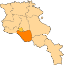
Urtsadzor (Armenian: Ուրցաձոր; formerly, Karabaghlar Nijneye (Azerbaijani: Aşağı Qarabağlar)), is a village in the Ararat Province of Armenia, containing the former village of Chimankend.
Urtsadzor Ուրցաձոր | |
|---|---|
 Urtsadzor | |
| Coordinates: 39°54′45″N 44°49′03″E | |
| Country | Armenia |
| Province | Ararat |
| Government | |
| Population (2008) | |
| • Total | 3,040 |
Nature
The village is located at semi-desert zone in the valley of Vedi River. There are about 15 pairs of White Storks breeding right in the village. Vicinity of the village have 131 species of butterflies and are recognized as Prime Butterfly Area.[1] Also number of bird species are recorded inside the village (e.g. Syrian Woodpecker, Levant Sparrowhawk, etc.) and its outskirts (e.g. Lanner Falcon, Grey-headed Bunting, Isabelline Wheatear, and others).[2]
gollark: Palaiologos clearly set 3 to 2 before running.
gollark: .
gollark: It's not specific enough for an address
gollark: What? Finland doesn't exist. This is nonsense.
gollark: Done.
See also
External links
- Urtsadzor at GEOnet Names Server
- World Gazeteer: Armenia – World-Gazetteer.com
- Report of the results of the 2001 Armenian Census, Statistical Committee of Armenia
This article is issued from Wikipedia. The text is licensed under Creative Commons - Attribution - Sharealike. Additional terms may apply for the media files.