Urraca Mesa
Urraca Mesa is a large mesa located in Colfax County in northern New Mexico, U.S., on the property of Philmont Scout Ranch. It reaches an elevation of 8,594 feet (2,619 m). The mesa has a long history of mythical and supernatural associations, dating to the local indigenous tribes.
| Urraca Mesa | |
|---|---|
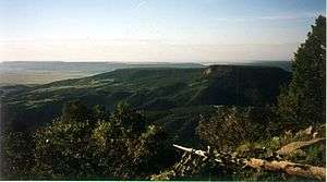 The mesa as seen from Tooth Ridge | |
| Highest point | |
| Elevation | 8,594 ft (2,619 m) NAVD 88[1] |
| Coordinates | 36°24′49″N 104°59′53″W [2] |
| Geography | |
 Urraca Mesa | |
| Location | Colfax County, New Mexico, U.S. |
| Topo map | USGS Coyote Mesa |
Name
The name comes from the Spanish word for magpie from ancient Native American legends.
Flora and fauna
The mesa is covered in Ponderosa pine. Black bears, wild turkeys, deer and mountain lions are among its inhabitants.
Topography
Urraca Mesa is relatively flat with the exception of a protruding plateau, which contains a freshwater source. It is known for having the highest number of lightning strikes anywhere in New Mexico.
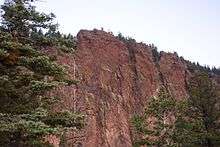
A nearly vertical cliff that makes up part of Urraca Mesa
gollark: What? The only information I can find on rwasa is some random politician.
gollark: (also I may eventually want to use ARM)
gollark: On the one hand I do somewhat want to run osmarksforum™ with this for funlolz, but on the other hand handwritten ASM is probably not secure.
gollark: > Well, the answer is a good cause for flame war, but I will risk. ;) At first, I find assembly language much more readable than HLL languages and especially C-like languages with their weird syntax. > At second, all my tests show, that in real-life applications assembly language always gives at least 200% performance boost. The problem is not the quality of the compilers. It is because the humans write programs in assembly language very different than programs in HLL. Notice, that you can write HLL program as fast as an assembly language program, but you will end with very, very unreadable and hard for support code. In the same time, the assembly version will be pretty readable and easy for support. > The performance is especially important for server applications, because the program runs on hired hardware and you are paying for every second CPU time and every byte RAM. AsmBB for example can run on very cheap shared web hosting and still to serve hundreds of users simultaneously.
gollark: https://board.asm32.info/asmbb/asmbb-v2-9-has-been-released.328/
References
- "Urraca Mesa, New Mexico". Peakbagger.com. Retrieved 2014-02-17.
- "Urraca Mesa". Geographic Names Information System. United States Geological Survey. Retrieved 2014-02-17.
This article is issued from Wikipedia. The text is licensed under Creative Commons - Attribution - Sharealike. Additional terms may apply for the media files.