Unwana
Unwana, also known as Unwara, is a town and the third-most important urban area in Ebonyi State, Nigeria. It is situated in the southern part of Ebonyi State. It is bordered in the north by Afikpo, in the west by Edda, and in the east by Cross River State. It is the seat of Akanu Ibiam Federal Polytechnic Unwana.
Unwana Ali Unwara light of the state
Unwara | |
|---|---|
City | |
 | |
 Unwana Location in Nigeria | |
| Coordinates: 5°51′45″N 7°56′55″E | |
| Country | |
| State | Ebonyi State |
| Population (2006) | |
| • Total | 120,000 |
| Unwana home of education | |
History and geographical study
Unwana is situated upon a hill and is the hometown of Ezeogo Dr Akanu Ibiam, the first governor of eastern Nigeria.
Unwana city is located in eastern Nigeria at Ebonyi state. It is located at latitude 5.7833' and longitude 7.9333'. Altitude 354 feet (107 m), lat (DMS) 5'46', long (DMS) 7'55'60E.
Unwana city is bounded on the west by cross-river state river, in the west by Afikpo.
Size
Unwana city has a total land area of approximately 190 km^2, but actually occupies 10% of the total land area.
People and population
The Igbo remains the largest tribe in Unwana city. As the place where Akanu Ibiam Federal Polytechnic is located and the capital of Ubeyi Development center. It also inhabits some of the tribes in the country. Although Unwana city is among the largest towns in Ebonyi state, as of 1991, the total population of Unwana was estimated at 120,000 people.
Geography

Unwana city is a highland area of 200 m above sea-level. The town can be divided into two sub-regions: the narrow lowland area with the Itara river and Ubeny river, and the low-narrow sandy beach.
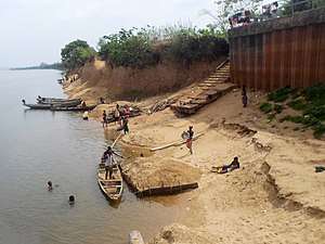
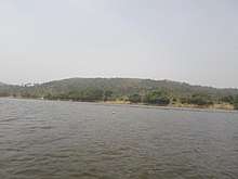
Unwana City is purely a riverine town. It has beaches like Unwana beach and Ozara Lake.
Economy
Inhabitants of Unwana City are involved in a large number of economic activities which include: small-scale industries, fishing, administration, commercial, transportation, trading and education.
Climate
Unwana City is located in the equatorial climate belt of Nigeria. It has a high temperature of between 27' and 38' with a low annual range of temperature. Rainfall is high with a maximum during June/July and September/October with a short August break. Humidity, due to its nearness to the river is moderate.
Unwana City has one vegetation belt which is the freshwater swamp.
Köppen-Geiger climate classification system classifies its climate as tropical wet and dry (Aw).[1]
| Climate data for Unwana | |||||||||||||
|---|---|---|---|---|---|---|---|---|---|---|---|---|---|
| Month | Jan | Feb | Mar | Apr | May | Jun | Jul | Aug | Sep | Oct | Nov | Dec | Year |
| Average high °C (°F) | 32.6 (90.7) |
33.8 (92.8) |
33.8 (92.8) |
33.4 (92.1) |
32 (90) |
30.8 (87.4) |
29.3 (84.7) |
28.6 (83.5) |
29.9 (85.8) |
30.8 (87.4) |
32.1 (89.8) |
32.6 (90.7) |
31.6 (89.0) |
| Daily mean °C (°F) | 27.5 (81.5) |
28.5 (83.3) |
29 (84) |
28.7 (83.7) |
27.6 (81.7) |
26.7 (80.1) |
25.4 (77.7) |
25.6 (78.1) |
26 (79) |
26.6 (79.9) |
27.4 (81.3) |
26.4 (79.5) |
27.1 (80.8) |
| Average low °C (°F) | 22.5 (72.5) |
23.2 (73.8) |
24.2 (75.6) |
24 (75) |
23.3 (73.9) |
22.6 (72.7) |
22.9 (73.2) |
22.7 (72.9) |
22.2 (72.0) |
22.4 (72.3) |
22.8 (73.0) |
22.8 (73.0) |
23.0 (73.3) |
| Average precipitation mm (inches) | 19 (0.7) |
34 (1.3) |
84 (3.3) |
159 (6.3) |
247 (9.7) |
261 (10.3) |
303 (11.9) |
270 (10.6) |
309 (12.2) |
269 (10.6) |
57 (2.2) |
15 (0.6) |
2,027 (79.7) |
| Source: Climate-Data.org (altitude: 62m)[1] | |||||||||||||
References
- "Climate: Unwana - Climate graph, Temperature graph, Climate table". Climate-Data.org. Retrieved 2014-02-20.