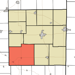
Union Township, Randolph County, Indiana
Union Township is one of eleven townships in Randolph County, Indiana, which contains the towns of Modoc and Losantville. As of the 2010 census, its population was 2,142 and it contained 960 housing units.[3]
Union Township | |
|---|---|
 Location of Union Township | |
| Coordinates: 40°2′39″N 85°7′41″W | |
| Country | United States |
| State | Indiana |
| County | Randolph |
| Government | |
| • Type | Indiana township |
| Area | |
| • Total | 71.65 sq mi (185.6 km2) |
| • Land | 71.52 sq mi (185.2 km2) |
| • Water | 0.13 sq mi (0.3 km2) |
| Elevation | 1,148 ft (350 m) |
| Population (2010) | |
| • Total | 2,142 |
| • Density | 30/sq mi (10/km2) |
| Time zone | UTC-5 (Eastern (EST)) |
| • Summer (DST) | UTC-4 (EDT) |
| Area code(s) | 765 |
| FIPS code | 18-77588[2] |
| GNIS feature ID | 453931 |
History
Union Township was established in 1838 from the merger of Nettle Creek Township and West River Township.[4]
Geography
According to the 2010 census, the township has a total area of 71.65 square miles (185.6 km2), of which 71.52 square miles (185.2 km2) (or 99.82%) is land and 0.13 square miles (0.34 km2) (or 0.18%) is water.[3]
Cities and towns
Unincorporated towns
- Huntsville at 40.0711567°N 85.0721876°W
- Scott Corner at 40.0919897°N 85.1269105°W
- Unionport at 40.1208783°N 85.0963553°W
(This list is based on USGS data and may include former settlements.)
Cemeteries
Union Township has nine cemeteries:
- Buena Vista Cemetery
- Huntsville Cemetery
- Little Creek Cemetery
- Nettle Creek Baptist Cemetery
- Riverside Cemetery
- Salem Cemetery
- Scott Cemetery
- Union Baptist Cemetery
- Union Chapel Cemetery
Major highways
gollark: Just use cryptography™ or qubes™.
gollark: Why would you do that?
gollark: They will have the *same* rate of dependency increase.
gollark: Imagine software projects add one dependency a year each for some reason. Imagine distro 1 only provides updates once a month, while distro 2 provides updates once a week.
gollark: Just because you get updates more often, doesn't mean the dependency counts increase more often.
References
- "US Board on Geographic Names". United States Geological Survey. 2007-10-25. Retrieved 2008-01-31.
- "U.S. Census website". United States Census Bureau. Retrieved 2008-01-31.
- "Population, Housing Units, Area, and Density: 2010 - County -- County Subdivision and Place -- 2010 Census Summary File 1". United States Census. Archived from the original on 2020-02-12. Retrieved 2013-05-10.
- Tucker, E. (1882). History of Randolph County, Indiana: With Illustrations and Biographical Sketches of Some of Its Prominent Men and Pioneers : to which are Appended Maps of Its Several Townships. A.L. Klingman. p. 50.
This article is issued from Wikipedia. The text is licensed under Creative Commons - Attribution - Sharealike. Additional terms may apply for the media files.