U.S. Route 29 in Georgia
U.S. Route 29 (US 29) in the state of Georgia, is a north–south United States Numbered Highway that runs southwest to northeast from West Point at the Alabama state line to the South Carolina state line, near Lake Hartwell. From West Point at the to downtown Atlanta, the Georgia Department of Transportation (GDOT) has cosigned US 29 with State Route 14 (SR 14). North of downtown Atlanta, the route runs along SR 8 to Dacula and again from west of Statham to the South Carolina state line.
| ||||
|---|---|---|---|---|
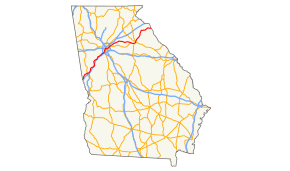 Route of US 29 highlighted in red | ||||
| Route information | ||||
| Maintained by GDOT | ||||
| Length | 207 mi (333 km) | |||
| Major junctions | ||||
| South end | ||||
| North end | ||||
| Location | ||||
| Counties | Troup, Coweta, Fulton, Clayton, DeKalb, Gwinnett, Barrow, Oconee, Clarke, Madison, Franklin, Hart | |||
| Highway system | ||||
| ||||

Concurrencies of US 29 with US routes in Georgia include US 27 in LaGrange as well as US 27 ALT from Moreland to Newnan. Others include US 19/US 41 from Castleberry Hill to the vicinity of Georgia Tech in Atlanta, US 78 from Georgia Tech to Scottdale, and again from near Bogart to Athens, US 278 from Georgia Tech to Druid Hills, US 23 from east Atlanta, to Decatur, and US 129/US 441 in the vicinity of Athens.
Route description
The following portions of US 29 in Georgia are part of the National Highway System, a system of routes determined to be the most important for the nation's economy, mobility, and defense:
- The concurrency with US 27/SR 1 in LaGrange
- From I-85 just south of East Newnan to SR 34 in Newnan
- From SR 74 in Fairburn to US 29 Alt./SR 14 Alt./SR 14 Conn. in Red Oak
- From I-20 in Atlanta to the intersection with Jimmy Carter Boulevard and Mountain Industrial Boulevard in Tucker
- From US 29 Bus./SR 8/SR 316 just west of Dacula to SR 72 in Athens[1][2][3]
History
Former sections of the road have included local streets named "Old Highway 29" in various locations as well as Broad Street (GA 14 Connector) in LaGrange[4][5] and U.S. Route 29 Business between Dacula and west of Statham. Other former segments include Old West Point Road south of LaGrange, Wynne-Russell Drive in Lilburn, Old Athens Road in Lawrenceville, Sam Groves Street in Danielsville, Old Royston Road in Bluestone, and Franklin Springs Circle in Royston.
Parts of US 29 to the southwest of Atlanta has been named Roosevelt Highway, since Franklin D. Roosevelt made his final journey northward from Warm Springs along this stretch of highway. Large crowds gathered along US 29 on this day in April 1945 to pay their final respects to the deceased President. Unfortunately for those who waited along the highway they missed seeing the president's body being transported back to Washington on a train that ran on nearby tracks.
Major intersections
| County | Location | mi | km | Exit | Destinations | Notes |
|---|---|---|---|---|---|---|
| Chambers | Lanett | 0.0 | 0.0 | Continuation into Alabama, southern end of SR 14 concurrency | ||
| Troup | West Point | John C. Barrow Bridge over the Chattahoochee River | US 29 leaves West 9th Street and becomes East 10th Street | |||
| Western terminus of SR 18 | ||||||
| LaGrange | Western end of SR 109 concurrency | |||||
| Western terminus of SR 14 Connector | ||||||
| Southern end of US 27/SR 1/SR 219 concurrency, eastern end of SR 109 concurrency | ||||||
| Eastern terminus of SR 14 Connector; northern end of SR 219 concurrency; Broad Street becomes Greenville Street east of US 27/29 | ||||||
| Northern end of US 27/SR 1 concurrency | ||||||
| Northern terminus of SR 14 Spur | ||||||
| Hogansville | Southern end of SR 100 concurrency | |||||
| Northern end of SR 100 concurrency | ||||||
| Coweta | Grantville | Exit 35 (I-85) | ||||
| Moreland | Northern terminus of SR 41, southern end of US 27 Alt. concurrency | |||||
| | Exit 41 (I-85) | |||||
| East Newnan | Southern end of SR 16 concurrency | |||||
| Newnan | Northern end of SR 16 concurrency | |||||
| Southern terminus of SR 70 | ||||||
| | Southern end of SR 154 concurrency | |||||
| Fulton | Palmetto | Southern terminus of US 29 Alt. and SR 14 Alt., northern end of SR 154 concurrency | ||||
| Fairburn | Northern terminus of SR 74 | |||||
| Union City | ||||||
| Red Oak | Northern terminus of US 29 Alt. and SR 14 Alt., western terminus of SR 14 Conn. | |||||
| College Park | Northern terminus of SR 279 | |||||
| Southern end of SR 139 concurrency | ||||||
| East Point | Southern end of SR 154 concurrency | |||||
| Atlanta | Northern end of SR 139 concurrency; | |||||
| Northern end of SR 14/SR 154 concurrency; southern end of SR 3 Connector concurrency | ||||||
| Sorthern end of US 19/US 41/SR 3 concurrency | ||||||
| Northern end of US 19/US 41/SR 3 concurrency; western end of US 78/US 278/SR 8 concurrency | ||||||
| I-75 exit 249D | ||||||
| Western end of SR 10 concurrency | ||||||
| Fulton–DeKalb county line | Western end of US 23 concurrency | |||||
| DeKalb | Druid Hills | Eastern end of US 278/SR 10 concurrency | ||||
| Decatur | Eastern end of US 23 concurrency | |||||
| Scottdale | Eastern end of US 78 concurrency | |||||
| North Druid Hills Road | To westbound Exit 1 on Stone Mountain Freeway | |||||
| Tucker | I-285 Exit 38 | |||||
| Southern end of SR 236 concurrency | ||||||
| Northern end of SR 236 concurrency | ||||||
| Gwinnett | Lilburn | Eastern terminus of SR 378 | ||||
| Lawrenceville | Lawrenceville–Suwanee Road | Future US 29 north[6] | ||||
| Western end of SR 20 concurrency | ||||||
| Eastern end of SR 20 concurrency; western end of SR 124 concurrency | ||||||
| Dacula | Eastern end of SR 8 concurrency; western end of SR 316 concurrency; western end of US 29 BUS; future US 29 south via University Parkway[6] | |||||
| Apalachee River | Unnamed bridge over the Apalachee River, which marks the Gwinnett–Barrow county line | |||||
| Barrow | Auburn | |||||
| Bethlehem | ||||||
| Russell | Eastern end of SR 11 concurrency | |||||
| | Eastern end of US 29 BUS; western end of SR 8 concurrency | |||||
| Statham | ||||||
| Oconee | | Western end of US 78 concurrency; western terminus of US 78 Bus.; interchange with no number | ||||
| | Eastern end of SR 316 concurrency; western end of SR 10 Loop/SR 422 concurrency; SR 10 Loop exit 1 | |||||
| Clarke | Athens | 4 | Western end of US 129/US 441/SR 15 concurrency | |||
| 6 | Southern terminus of SR 15 Alt.; provides access to University Health Center | |||||
| 7 | College Station Road – University of Georgia | |||||
| 8 | Eastern end of US 78 concurrency; eastern terminus of US 78 Bus. | |||||
| 9 | Peter Street / Olympic Drive | |||||
| 10A | Old Hull Road | |||||
| 10B-D | Eastern end of SR 10 Loop/SR 422 and US 129/US 441/SR 15 concurrencies | |||||
| Western terminus of SR 72 | ||||||
| Madison | Hull | Southern terminus; northern terminus of former SR 393 | ||||
| | Garnett Ward Road | Former GA 182 | ||||
| Danielsville | ||||||
| | ||||||
| | ||||||
| Bond | Western end of SR 174 concurrency | |||||
| Hudson River | Unnamed bridge over the Hudson River, which marks the Madison–Franklin county line | |||||
| Franklin | | Eastern end of SR 174 concurrency | ||||
| Franklin Springs | ||||||
| Royston | ||||||
| Hart | ||||||
| Hartwell | Western end of SR 51/SR 77 concurrency | |||||
| Eastern end of SR 51 concurrency | ||||||
| Eastern end of SR 77 concurrency | ||||||
| | ||||||
| Savannah River | Hartwell Dam Bridge at Georgia–South Carolina state line, SR 8 concurrency ends | |||||
| 207 | 333 | US 29 continues into South Carolina. | ||||
1.000 mi = 1.609 km; 1.000 km = 0.621 mi
| ||||||
See also

.svg.png)
References
- National Highway System: Georgia (PDF) (Map). Federal Highway Administration. May 8, 2019. Retrieved August 11, 2019.
- National Highway System: Atlanta, GA (PDF) (Map). Federal Highway Administration. May 9, 2019. Retrieved August 11, 2019.
- National Highway System: Athens-Clarke County, GA (PDF) (Map). Federal Highway Administration. May 9, 2019. Retrieved August 11, 2019.
- State Highway Department of Georgia (January 1970). Official Highway Map (PDF) (Map). Scale not given. Atlanta: State Highway Department of Georgia.
- State Highway Department of Georgia (January 1971). Official Highway Map (PDF) (Map). Scale not given. Atlanta: State Highway Department of Georgia.
External links
| Wikimedia Commons has media related to U.S. Route 29 in Georgia (U.S. state). |
- U.S. Highway 29 & Georgia 8 (AARoads.com)
- 29 US 29 (Georgia Highways)
- US 29 in Georgia (Mile-by-Mile)
| Previous state: Alabama |
Georgia | Next state: South Carolina |