Tualatai County
Tūalātai County is a county in the Western District in American Samoa.[1][2][3]
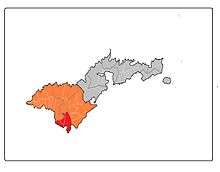
Map of Tutuila where Tūalātai County is highlighted in red, while the Western District is marked in orange.
Vailoatai, Taputimu, Fūtiga and Malaeloa (Itū'au) are located in Tūalātai County.
Demographics
| Year | Pop. | ±% |
|---|---|---|
| 1912 | 290 | — |
| 1920 | 333 | +14.8% |
| 1930 | 437 | +31.2% |
| 1940 | 527 | +20.6% |
| 1950 | 844 | +60.2% |
| 1960 | 1,008 | +19.4% |
| 1970 | 1,565 | +55.3% |
| 1980 | 2,171 | +38.7% |
| 1990 | 2,568 | +18.3% |
| 2000 | 2,987 | +16.3% |
| 2010 | 3,561 | +19.2% |
| U.S. Decennial Census[4] | ||
Tūalātai County was first recorded beginning with the 1912 special census. Regular decennial censuses were taken beginning in 1920.[5]
Villages
gollark: And would it be easier in Windows? It generally swaps the terminal for cryptic registry entries, dubious third-party software, and mysterious settings buried deep in control panel.
gollark: What stuff did you *need* to configure using a terminal?
gollark: GUI ones I mean.
gollark: There are a decent amount of tools available for configuring lots of software.
gollark: How?
References
- "CPH-T-8. Population, Housing Units, Land Area, and Density for U.S. Island Areas: 2010" (PDF). United States Census. Retrieved 4 February 2019.
- 1987 Census of Agriculture: Geographic area series, Parts 55-56. Bureau of the Census. p. 4.
- "5.0102 Division of districts into counties". www.asbar.org.
- "U.S. Decennial Census". Census.gov. Retrieved June 6, 2013.
- https://www2.census.gov/prod2/decennial/documents/41084484v3ch10.pdf
This article is issued from Wikipedia. The text is licensed under Creative Commons - Attribution - Sharealike. Additional terms may apply for the media files.