Trugberg
The Trugberg is a mountain in the Bernese Alps, located south of the Mönch in the canton of Valais, Switzerland. It is located above the Konkordiaplatz where the névé of the Jungfraufirn on the west side and the Ewigschneefeld on the east side converge to form the Aletsch Glacier. Debris accumulating on both sides of the mountain form one of the two important supraglacial moraines of the Aletsch Glacier.
| Trugberg | |
|---|---|
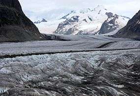 Trugberg (right) from the Aletsch Glacier | |
| Highest point | |
| Elevation | 3,933 m (12,904 ft) |
| Prominence | 306 m (1,004 ft) [1] |
| Parent peak | Mönch |
| Isolation | 1.7 km (1.1 mi) |
| Listing | Alpine mountains above 3000 m |
| Coordinates | 46°32′50″N 8°00′56″E |
| Geography | |
 Trugberg Location in Switzerland | |
| Location | Valais, Switzerland |
| Parent range | Bernese Alps |
| Climbing | |
| First ascent | 1871 |
During their ascent of the Jungfrau in 1841, a group of explorers including Pierre Jean Édouard Desor and Louis Agassiz for a while thought that the Trugberg, hiding the Jungfrau from sight, was their destination. Eventually, they realized their error and decided to name the mountain Trugberg, meaning Deceitful Mountain.[2]
The Trugberg was first climbed 13 July 1871 by Dr. Emil Burckardt from Basel, with the two local guides Peter Egger and Peter Schlegel. The route they took was by the east flank.
References
- Retrieved from the Swisstopo topographic maps. The key col is the Obers Mönchsjoch (3,627 m).
- Swiss mountains names www.swissworld.org. Retrieved 2010-04-05