Tropical Depression 18W (2009)
Tropical Depression 18W was a weak, short-lived tropical cyclone that brought heavy rains to parts of the Mariana Islands ahead of the more intense Typhoon Melor. Forming from an area of low pressure on September 26, 18W was first monitored by the Japan Meteorological Agency (JMA) as a tropical depression. Tracking generally towards the west, deep convection gradually developed around the system and the Joint Typhoon Warning Center (JTWC) issued their first advisory on the depression early on September 28. Although the depression initially struggled to maintain deep convection, it eventually became better organized and was upgraded to a tropical storm on September 29 by the JTWC. Several hours after reaching this intensity, the system began to rapidly dissipate as its inflow and outflow were severely disrupted by two nearby storms, Parma to the west and Melor to the east. The cyclone fully dissipated near Guam early on September 30 before being absorbed by Typhoon Parma.
| Tropical depression (JMA scale) | |
|---|---|
| Tropical depression (SSHWS) | |
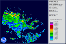
 Tropical Depression 18W at peak intensity on September 29 | |
| Formed | September 26, 2009 |
| Dissipated | September 30, 2009 |
| Highest winds | 10-minute sustained: 55 km/h (35 mph) 1-minute sustained: 55 km/h (35 mph) |
| Lowest pressure | 1000 hPa (mbar); 29.53 inHg |
| Fatalities | None Reported |
| Damage | Minimal |
| Areas affected | Mariana Islands and Guam |
| Part of the 2009 Pacific typhoon season | |
Ahead of the system's arrival in Guam, tropical storm watches and warnings were issued by the National Weather Service. On September 29, a state of emergency was declared by Governor Felix P. Camacho and relief funds were allocated in case of damage after the storm. Due to the low-intensity of the storm, it had little impact on Guam. Only increased winds and moderate rainfall were reported.
Meteorological history

The storm originated from an area of low pressure on September 24 that formed roughly 725 km (450 mi) east-northeast of Pohnpei. Deep convection had developed in association with the low and was beginning to wrap around the center of circulation.[1][2][3] By September 26, the system had developed strong outflow and was intensifying.[4] Later that day, the Japan Meteorological Agency (JMA) began monitoring the low as a tropical depression.[5] The following day, the Joint Typhoon Warning Center (JTWC) issued their first advisory on the depression.[2] At this time, it was being steered towards the west in response to a mid-level ridge to the north.[6] Little intensification took place as convection barely deepened around the low-level circulation; however, the JTWC anticipated the system to intensify into a tropical storm within 24 hours.[7]
Although conditions for intensification were present, convection associated with the depression weakened significantly by September 28. Forecasts for the system became increasingly complicated due to the formation of Tropical Depression Nineteen-W to the east-south-east.[8] Later that day, the motion of the storm shifted to the west-northwest in response to a subtropical ridge north of the depression. The center of circulation had become nearly devoid of convection late on September 28, with only the western portion of the system featuring shower and thunderstorm activity.[9] By the morning of September 29, convection redeveloped around the center of 18W and the JTWC determined that the system had intensified into a tropical storm, with winds peaking at 65 km/h (40 mph 1-minute sustained).[10] However, in post storm analysis, the JTWC determined that the depression had not intensified into a tropical storm and lowered the peak wind-speeds to 55 km/h (35 mph).[1][11]
Around the time the system was upgraded to a tropical storm by the JTWC, the JMA assessed it to have reached its peak intensity as a strong tropical depression with winds of 55 km/h (35 mph 10-minute sustained) and a barometric pressure of 999 mbar (hPa).[1][2][12] Struggling to maintain deep convection, the system's inflow and outflow patterns became severely disrupted by two intensifying cyclones, Parma to the west and Melor to the west. The combined effects of the two other storms eventually left the center of 18W devoid of convection as it approached Guam.[13] As it passed near the island, the storm rapidly dissipated, first weakening to a depression and then losing its low-level circulation. It was no longer considered a tropical cyclone a few hours after brushing Guam. This coincided with the issuance of the final warnings from the JTWC and the JMA.[1][2][14][15]
Preparations and impact

Several hours after being classified a tropical depression on September 29, the National Weather Service issued a tropical storm watch for the islands of Guam and Rota.[16] Later that day, the watches were upgraded to warnings as 18W intensified into a tropical storm.[17] The same day, the emergency operations center on Guam was fully activated. Public schools on the island were closed by officials until further notice.[18] Although warnings were issued for the Mariana Islands, most residents did not heed warnings. Stores selling supplies such as plywood, lumber, nails, screws, batteries and butane stoves reported only a slight increase in sales. There were also no sales of flashlights and generators ahead of the system. Although most did not prepare fully, one resident told news reporters "We haven't been hit in a while so...I'm going to prepare."[19] Twelve shelters were opened across the island; however, they did not have supplies and people were advised to bring at least three days worth of food and water.[20]

Just prior to the arrival of the storm, Governor Felix P. Camacho declared a state of emergency for the island of Guam and allocated $250,000 in funds for relief efforts. A tropical cyclone condition of readiness (TCCOR), a warning scale used by the military on the island, was placed at level one, the highest on the scale.[21] Rota was also placed under a TCCOR at level 3.[22] By the afternoon of September 29, roughly 250 residents had sought refuge in shelters across the island. All flights to and from Guam were canceled[21] and the Team Anderson Air Show was rescheduled.[23] Five ships and a submarine from the United States Navy moved out to sea to avoid the storm; however, one submarine was unable to leave and remained at port during the storm.[24] A total of 100 people from the Red Cross disaster team were deployed in Guam to prepare for any damage caused by the storm.[25]
During the storm, the National Weather Service issued an urban and small stream flood advisory due to the likelihood of heavy rains.[26] Late on September 29 through the morning of September 30, 18W brought high winds and heavy rains to Guam and nearby Rota as it tracked between the two islands.[27] Shortly after the storm passed by, the Governor Felix Camacho issued a press statement lowering the TCCOR to level 4. All tropical storm warnings were also canceled at this time. With this, shelters began to scale down operations and were set to close at 5:00 pm local time on September 30.[28]
See also
- 2009 Pacific typhoon season
- Timeline of the 2009 Pacific typhoon season
- Typhoon Parma (2009)
References
- Staff. "Tropical Depression 18W best track". Joint Typhoon Warning Center. Retrieved July 10, 2013.
- Mayers, John. Annual Tropical Cyclone Report - 2009 (PDF) (Report). Joint Typhoon Warning Center. p. 33. Retrieved July 10, 2013.
- "Significant Tropical Weather Outlook for the Western and South Pacific Oceans". Joint Typhoon Warning Center. September 24, 2009. Retrieved October 2, 2009.
- "Significant Tropical Weather Outlook for the Western and South Pacific Oceans". Joint Typhoon Warning Center. September 26, 2009. Retrieved October 2, 2009.
- "WWJP25 RJTD 260600". Japan Meteorological Agency. September 26, 2009. Retrieved October 2, 2009.
- "Tropical Depression 18W Advisory 001". Joint Typhoon Warning Center. September 27, 2009. Retrieved October 2, 2009.
- "Tropical Depression 18W Advisory 003". Joint Typhoon Warning Center. September 28, 2009. Retrieved October 2, 2009.
- "Tropical Depression 18W Advisory 005". Joint Typhoon Warning Center. September 28, 2009. Retrieved October 2, 2009.
- "Tropical Depression 18W Advisory 007". Joint Typhoon Warning Center. September 28, 2009. Retrieved October 2, 2009.
- "Tropical Storm 18W Advisory 009". Joint Typhoon Warning Center. September 29, 2009. Retrieved October 4, 2009.
- "Tropical Storm 18W Advisory 009". Joint Typhoon Warning Center. March 1, 2010. Retrieved March 1, 2010.
- "WWJP25 RJTD 281800". Japan Meteorological Agency. September 28, 2009. Retrieved October 4, 2009.
- "Tropical Storm 18W Advisory 11". Joint Typhoon Warning Center. September 29, 2009. Retrieved October 4, 2009.
- "Tropical Depression 18W Advisory 13 (Final)". Joint Typhoon Warning Center. September 30, 2009. Retrieved October 4, 2009.
- "WWJP25 RJTD 301200". Japan Meteorological Agency. September 30, 2009. Retrieved October 4, 2009.
- Dan Mundell (September 29, 2009). "Tropical Depression 18W Bulletin Number Two-A". National Weather Service in Tiyan, Guam. Archived from the original on September 27, 2009. Retrieved October 3, 2009.
- Dan Mundell (September 29, 2009). "Tropical Storm 18W Advisory Number Nine". National Weather Service in Tiyan, Guam. Archived from the original on September 29, 2009. Retrieved October 3, 2009.
- Mana Silva Taijeron (September 29, 2009). "Guam In COR1; Public Schools GovGuam Offices Closed". Pacific News Center. Archived from the original on October 3, 2009. Retrieved October 3, 2009.
- Laura Matthews (September 30, 2009). "Few residents stocking up for tropical storm". Pacific Daily News: Guam. Archived from the original on October 3, 2009. Retrieved October 3, 2009.
- "Tropical Storm 18W: Island Shelters to Open at 9am Today". Pacific News Center. September 29, 2009. Archived from the original on October 3, 2009. Retrieved October 3, 2009.
- "Governor Declares State of Emergency For 18W". Pacific News Center. September 29, 2009. Archived from the original on October 3, 2009. Retrieved October 3, 2009.
- Emergency Management Office (September 29, 2009). "Rota on Tropical Storm Condition 3". Saipan Tribune. Archived from the original on October 3, 2009. Retrieved October 3, 2009.
- Heather Hauswirth (October 5, 2009). "Thunderbirds to take Guam hero up, up & away". KUAM News. Retrieved July 9, 2013.
- CNN (September 30, 2009). "Navy Vessels Set Sail To Avoid Tropical Depression Near Guam". wibw. Archived from the original on October 3, 2009. Retrieved October 3, 2009.
- Laura Matthews (October 1, 2009). "Red Cross volunteers placed on standby". Pacific Daily News: Guam. Archived from the original on October 3, 2009. Retrieved October 3, 2009.
- National Weather Service (September 29, 2009). "NWS issues urban & small stream flood advisory". Kuam News. Retrieved October 3, 2009.
- Kevin Kerrigan (September 30, 2009). "NWS: Storm With No Name Has No Punch". Pacific News Center. Archived from the original on October 3, 2009. Retrieved October 3, 2009.
- "Tropical storm warning cancelled; Guam back in Condition of Readiness 4". Pacific Daily News. September 30, 2009. Archived from the original on October 3, 2009. Retrieved October 3, 2009.
