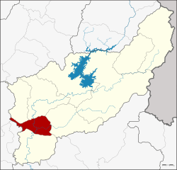
Tron District
Tron (Thai: ตรอน, pronounced [trɔ̄ːn]) is a district (amphoe) of Uttaradit Province, northern Thailand.
Tron ตรอน | |
|---|---|
 District location in Uttaradit Province | |
| Coordinates: 17°28′56″N 100°6′47″E | |
| Country | Thailand |
| Province | Uttaradit |
| Seat | Wang Daeng |
| Area | |
| • Total | 314.501 km2 (121.430 sq mi) |
| Population (2008) | |
| • Total | 35,036 |
| • Density | 113.6/km2 (294/sq mi) |
| Time zone | UTC+7 (ICT) |
| Postal code | 53140 |
| Geocode | 5302 |
Geography
Neighboring districts are (from the north clockwise) Laplae, Mueang Uttaradit, Thong Saen Khan, Phichai, of Uttaradit Province, Si Nakhon and Si Satchanalai of Sukhothai Province
Administration
The district is divided into five sub-districts (tambons), which are further subdivided into 47 villages (mubans). There are two sub-district municipalities (thesaban tambon): Tron covers parts of tambon Wang Daeng, and Ban Kaeng covers parts of the same-named tambon. There are a further five tambon administrative organizations (TAO).
| No. | Name | Thai | Villages | Pop.[1] |
|---|---|---|---|---|
| 1. | Wang Daeng | วังแดง | 12 | 11,091 |
| 2. | Ban Kaeng | บ้านแก่ง | 10 | 7,567 |
| 3. | Hat Song Khwae | หาดสองแคว | 7 | 4,148 |
| 4. | Nam Ang | น้ำอ่าง | 10 | 7,975 |
| 5. | Khoi Sung | ข่อยสูง | 8 | 4,255 |
gollark: Macbooks cost more, but are actually very good now.
gollark: Oh. Chromebooks cost less than "good" laptops, though.
gollark: Anyway, what do you mean "lightbook"?
gollark: Yes.
gollark: Well, mine has a GPU.
References
- "Population statistics 2008". Department of Provincial Administration. Archived from the original on 2009-08-20.
External links
- amphoe.com (Thai)
This article is issued from Wikipedia. The text is licensed under Creative Commons - Attribution - Sharealike. Additional terms may apply for the media files.