Triouzoune
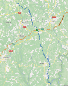
The Triouzoune (Occitan: Triusona) is a 50.5 km (31.4 mi) long river in the Corrèze département, south-central France. Its source is on the Plateau de Millevaches, 1 km (0.62 mi) north of la Rigaudie, a hamlet in Saint-Sulpice-les-Bois. It flows generally south-southeast. It is a right tributary of the Dordogne into which it flows between Neuvic and Sérandon.
| Triouzoune | |
|---|---|
 | |
| Location | |
| Country | France |
| Physical characteristics | |
| Source | |
| • location | Saint-Sulpice-les-Bois |
| • coordinates | 45°37′07″N 02°07′32″E |
| • elevation | 870 m (2,850 ft) |
| Mouth | |
• location | Dordogne |
• coordinates | 45°18′40″N 02°18′14″E |
• elevation | 340 m (1,120 ft) |
| Length | 50.5 km (31.4 mi) |
| Basin size | 130 km2 (50 sq mi) |
| Discharge | |
| • average | 1.76 m3/s (62 cu ft/s) |
| Basin features | |
| Progression | Dordogne→ Gironde estuary→ Atlantic Ocean |
Communes along its course
This list is ordered from source to mouth: Saint-Sulpice-les-Bois, Saint-Germain-Lavolps, Meymac, Alleyrat, Saint-Angel, Valiergues, Palisse, Neuvic, Liginiac, Sérandon
Notes
- This article is based on the equivalent article from the French Wikipedia, consulted on 11 April 2009.
gollark: That would probably be hard to run in real time on-device and would probably not matter if you're exploiting it anyway.
gollark: The consumer things will inevitably have poor security, probably backdoors, and the ability to accept feeds you don't really want for advertising.
gollark: It probably isn't just that, you can get fairly cheap tablets; probably people just don't want to carry around and manage data on two devices.
gollark: Do you just somehow always manage to not go anywhere with worse internet?
gollark: Well, I can't fix it easily, practically and legally.
This article is issued from Wikipedia. The text is licensed under Creative Commons - Attribution - Sharealike. Additional terms may apply for the media files.