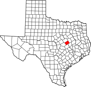
Travis, Texas
Travis is an unincorporated community in southeast Falls County, Texas, United States. It is named after Travis Fleming Jones, who surveyed the site for the San Antonio and Aransas Pass Railway in the 1880s. Travis Krause is also believed to be connected to the city. The population was up to 300 in the 1920s and 1930s, but has decreased to 60 by 1990 and has steadily remained at that figure since.
Travis, Texas | |
|---|---|
Unincorporated community | |
 Travis  Travis | |
| Coordinates: 31°8′7″N 97°0′9″W | |
| Country | |
| State | |
| County | |
| Elevation | 473 ft (144 m) |
| Population (2000) | |
| • Total | 60 |
| Time zone | UTC-6 (Central (CST)) |
| • Summer (DST) | UTC-5 (CDT) |
| ZIP code | 76656 |
| Area code(s) | 254 |
| FIPS code | 48-46740[1] |
| GNIS feature ID | 1362189[2] |
Education
Travis is home to Rosebud-Lott High School, part of the Rosebud-Lott I.S.D.
gollark: RDanny being in python means I could steal code, although mostly I just steal rough design.
gollark: andrew: [REDÄCTED]
gollark: Python!
gollark: 2791.
gollark: Anyway, PotatOS Advanced Projects™ actually does quite a lot of stuff. There's also GTech's Antimemetics Division, which works on it a fair bit (primarily the Microsoft-branded edition, as part of our partnership with Microsoft/Vartax), PotatOS Cloud-Scale Blockchain/AI Quantum Agile Disruptive Engineering (web APIs), PotatOS Paralegalistics (works on stuff like the privacy policy and SCP-2791), [LEVEL 5 CLEARANCE REQUIRED] (Project TANTALUM IGUANA), PotatOS ⬡, and many other teams working on potatOS.
References
- "U.S. Census website". United States Census Bureau. Retrieved 2008-01-31.
- "US Board on Geographic Names". United States Geological Survey. 2007-10-25. Retrieved 2008-01-31.
This article is issued from Wikipedia. The text is licensed under Creative Commons - Attribution - Sharealike. Additional terms may apply for the media files.
