Trans-Taiga Road
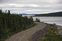
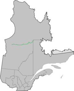
The Trans-Taiga Road (French: Route Transtaïga) is an extremely remote wilderness road in northern Quebec, Canada. It is 582 kilometres (362 mi) long to Centrale Brisay and another 84 kilometres (52 mi) along the Caniapiscau Reservoir, all of it unpaved.


The road's northeastern terminus is almost at the 55th parallel north, making it the northernmost continuous road in Eastern North America. Though the terminus is also the farthest point from any town (745 kilometres (463 mi) from Radisson) via road in North America, it is nonetheless relatively close – 190 kilometres (120 mi) – to Schefferville geographically. It does not, however, provide access to it, as the intervening terrain is impassable even in an all-terrain vehicle. The road's end is also close to the southern limit of Nunavik, Quebec's Inuit region which is negotiating for autonomous status within Quebec.
The Trans-Taiga Road branches off from the James Bay Road (French: Route de la Baie James) at kilometer 544. It was built as an access road to the hydro-electric generating stations of Hydro-Québec along the La Grande River and Caniapiscau River. Several outfitters are established along this road, providing wilderness hunting and fishing expeditions, and some may also provide fuel, food and lodging. Otherwise, there are no services along this road.
While the Trans-Taiga Road is reportedly drivable by ordinary passenger vehicles for its entire length, Hydro-Québec recommends use of 4WD vehicles for the section between Brisay and Caniapiscau, which is of a rougher grade than the rest of the road.
As the name of the road indicates, this road winds its way through Quebec's vast boreal forest, characterized by stunted spruce and pine, bogs and rocky outcroppings. Taiga is the Russian term for the same type of forest.
Regional and provincial officials have suggested building a link from the road's northeastern terminus in Caniapiscau to Kuujjuaq, several hundred kilometres to the north in Nunavik, also accessing Schefferville along the way. As the road east of Centrale Brisay is extremely rough (large rocks on the road surface), part of the existing road would also require upgrade; an extension via Schefferville would likely require crossing the province of Newfoundland and Labrador.
Waypoints
| Km | Mi | |
|---|---|---|
| 0 | 0 | Start of Trans-taiga Road at km 544 of the James Bay Road |
| 23 | 14 | Emergency telephone |
| 56 | 35 | Sakami Lake |
| 62 | 39 | Robert-Bourassa Reservoir |
| 100 | 62 | junction with access road to La Grande-3 generating station, 30 km (19 mi) north |
| 286 | 178 | Caladonia Lake, Nouchimi Outfitter, fuel available (as of August 2013: Nouchimi is closed, fuel available at CargAir depot 500m up the road) |
| 292 | 181 | La Grande-4 Airport |
| 311 | 193 | junction with access road to La Grande-4 generating station, 5 km (3.1 mi) north |
| 358 | 222 | Mirage Outfitter and Pourvoirie Mirage Aerodrome, fuel available |
| 395 | 245 | junction with access road to Laforge-1 generating station, 38 km (24 mi) north |
| 525 | 326 | junction with access road to Laforge-2 generating station, 6 km (3.7 mi) north |
| 582 | 362 | Brisay generating station |
| 666 | 414 | End of Transtaiga Road, Caniapiscau Reservoir |
- Source: Live through enormous: Visit the James Bay, Municipalité de Baie-James, February 2005.
External links
| Wikimedia Commons has media related to Route Transtaïga. |
- Unofficial site, part of the James Bay Road site
- Plan by Quebec Provincial government includes study of a possible extension to Kuujjuaq.
- Mirage Outfitter