Tortiya
Tortiya is a town in northern Ivory Coast. It is a sub-prefecture and commune of Niakaramandougou Department in Hambol Region, Vallée du Bandama District. The town sits just east of the border of Savanes District.
Tortiya | |
|---|---|
Town, sub-prefecture, and commune | |
 Tortiya Location in Ivory Coast | |
| Coordinates: 8°46′N 5°41′W | |
| Country | |
| District | Vallée du Bandama |
| Region | Hambol |
| Department | Niakaramandougou |
| Population (2014)[1] | |
| • Total | 22,124 |
| Time zone | UTC+0 (GMT) |
In 2014, the population of the sub-prefecture of Tortiya was 22,124 [2].
Villages
The 11 villages of the sub-prefecture of Tortiya and their population in 2014 are
- Kationron (646)
- Tortiya (15 998)
- Zouaéri (242)
- Allasso (306)
- Gninlnafolokaha (892)
- Lotialga (886)
- Nabédjakaha (679)
- Sangadjokaha (458)
- Songorokaha (304)
- Ténindiéri (781)
- Zanakaha (932)
Notes
- "Côte d'Ivoire". geohive.com. Retrieved 14 December 2015.
- "RGPH 2014, Répertoire des localités, Région Hambol" (PDF). ins.ci. Retrieved 5 August 2019.
Regional seat: Katiola | ||
| Dabakala Department | 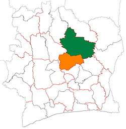 | |
| Katiola Department | ||
| Niakaramandougou Department | ||
* also a commune | ||
gollark: Yeees, the NHS has efficiency issues.
gollark: Yes, vote liberal democrats except haha your vote is meaningless because FPTP and gerrymandered constituencies.
gollark: Apparently good dry humor.
gollark: Also an economy which works?
gollark: And saner leaders than the US.
This article is issued from Wikipedia. The text is licensed under Creative Commons - Attribution - Sharealike. Additional terms may apply for the media files.