Tornado outbreak of August 6, 1969
The tornado outbreak of August 6, 1969, also known as the 1969 Minnesota tornado outbreak and the 1969 North Woods tornado outbreak,[3] was a tornado outbreak that affected portions of north central Minnesota on August 6, 1969. There were 13 confirmed tornadoes from the outbreak, 15 people were killed and 109 were injured.[nb 2] To date, the outbreak remains the deadliest on record in the North Woods region of Minnesota.[3][5]
Part of the tornado outbreaks of 1969 | |
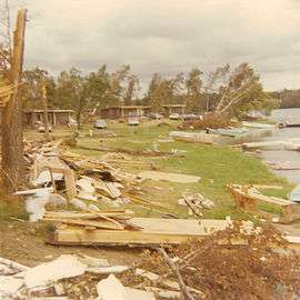 Damage to cabins near the current Lake Roosevelt Resort just north of Outing, Minnesota, from the F4 tornado. Damage in the photo is not indicative of maximum intensity. | |
| Type | Tornado outbreak |
|---|---|
| Duration | August 6, 1969 |
| Tornadoes confirmed | 13 |
| Max. rating1 | F4 tornado |
| Duration of tornado outbreak2 | 7 hours, 25 minutes |
| Highest gust | 60 kn (69 mph; 110 km/h) in Iowa[1] |
| Largest hail | 1 in (2.5 cm) in Clearwater County, Minnesota[2] |
| Damage | ~$4.27 million (1969 USD)[nb 1] |
| Casualties | 15 fatalities, 109 injuries |
| Areas affected | Minnesota, Nebraska |
| 1Most severe tornado damage; see Fujita scale 2Time from first tornado to last tornado | |
Background
Very warm, humid, summertime air had pushed into central and southern Minnesota on August 6, 1969. Minneapolis recorded a high temperature of 93 °F (34 °C) with dew points near 70 °F (21 °C). Meanwhile, strong upper-level winds over northern Minnesota and an approaching cold front from the west added the needed ingredient for the strong storms.[3] Two distinct thunderstorms formed approximately 45 mi (72 km) apart and tracked east-northeastward across Minnesota at 50 mph (80 km/h).[6] These parallel storms generated thirteen tornadoes, killing fifteen people and injuring 109.
The first tornado of the day, rated F0, touched down at 1:15 p.m. CDT (12:15 p.m. CST; 18:15 UTC) in Beltrami County.[3][7] The main tornado event started about three hours later in Cass County when an F3 tornado touched down southwest of Backus, injuring four people.[8] The most damaging tornado of the outbreak touched down at 4:48 p.m. CDT (3:48 p.m. CST; 21:48 UTC) in Crow Wing County. It achieved F4 strength, traveling 38 miles (61 km) through Crow Wing, Cass and Aitkin counties. The area around Outing was especially hard hit by this tornado, where eleven deaths and forty injuries occurred on the shores of Roosevelt Lake.[3]
Several more strong tornadoes touched down over the next two hours, killing one person near Jacobson and two people near Two Harbors.[3] Damage and casualties were limited however because most of the twisters struck rural areas.
Daily statistics
| FU | F0 | F1 | F2 | F3 | F4 | F5 | Total |
|---|---|---|---|---|---|---|---|
| 0* | 1 | 0 | 3 | 8 | 1 | 0 | 13 |
| "FU" denotes unclassified but confirmed tornadoes. | |||||||
| Date | Total | Fujita scale rating | Deaths | Injuries | Damage | Ref. | ||||||
|---|---|---|---|---|---|---|---|---|---|---|---|---|
| FU | F0 | F1 | F2 | F3 | F4 | F5 | ||||||
| April 1 | 13 | 0 | 1 | 0 | 3 | 8 | 1 | 0 | 15 | 109 | $4,265,000 | [9][10][11] |
| Total | 13 | 0 | 1 | 0 | 3 | 8 | 1 | 0 | 15 | 109 | $4,265,000 | [9][10][11] |
| State | Total | County | County total |
|---|---|---|---|
| Minnesota | 15 | Aitkin | 1 |
| Cass | 12 | ||
| St. Louis | 2 | ||
| Totals | 15 | ||
| All deaths were tornado-related | |||
- At least one additional tornado occurred near Bear Island Lake in St. Louis County, Minnesota, at around 6:30 p.m. CDT (5:30 p.m. CST; 23:30 UTC), and produced losses of about $10,000,[12][13] but was not officially listed.[9]
Confirmed tornadoes
August 6 event
| F# | Location | County / Parish | State | Start coord. |
Time (UTC) | Path length | Max. width | Summary |
|---|---|---|---|---|---|---|---|---|
| F0 | Bemidji area | Beltrami | MN | 47.50°N 94.85°W | 18:15–? | 0.1 miles (0.16 km) | N/A | A short-lived waterspout affected Lake Bemidji.[15] |
| F3 | NE of Nimrod to ENE of Backus | Cass | MN | 46.72°N 94.73°W | 21:20–21:40 | 17.3 miles (27.8 km) | N/A | This strong tornado first touched down northeast of Nimrod and lifted at the southeastern corner of Big Portage Lake.[8] The tornado significantly damaged or destroyed thirteen farms to the southeast of Backus.[16] Additionally, it destroyed 11 homes to the east of Backus.[15] One trailer was destroyed as well.[16] Four people were seriously injured and hospitalized, and damages totalled $850,000.[15] |
| F4 | NW of Swanburg to SE of Hill City | Crow Wing, Cass, Aitkin | MN | 46.78°N 94.22°W | 21:48–22:28 | 32.3 miles (52.0 km) | 2,640 yd (2,410 m) | 12 deaths – This large, violent tornado attained a width of almost 1 mi (2 km) while passing through Outing.[12] The area around Lake Roosevelt saw 11 of the 12 deaths as well as about 40 children sustaining injuries while vacationing.[16] Along its path, the tornado hurled cars and downed thousands of trees, many of which were debarked. The tornado also destroyed scores of cabins and leveled farms.[16] In all, 70 people were injured, and losses reached $2.15 million.[12] The death toll may have exceeded 12.[16] |
| F3 | NNE of Chisholm to S of Idington | St. Louis | MN | 47.60°N 92.83°W | 22:25–22:38 | 10 miles (16 km) | 3,520 yd (3,220 m) | This tornado reportedly exceeded 2 mi (3 km) in width.[6] It destroyed numerous trees, homes, and cabins. Nine people were injured, and losses reached $675,000.[16] The tornado ended just north of Big Sandy Lake.[12] In his reanalysis, researcher Thomas P. Grazulis listed the tornado as an F2.[16] |
| F3 | SE of Hill City to ESE of Ball Bluff | Aitkin | MN | 46.90°N 93.45°W | 22:50–23:03 | 12.5 miles (20.1 km) | N/A | 1 death – This tornado formed from the same storm as the previous tornado, and passed near Jacobson. It destroyed two homes and seven outbuildings on farms, and killed one person in a small cabin.[12][16] Losses reached $250,000. The number of injuries was unknown at the time, but was later listed as three in official records.[12][16][17] Grazulis listed this tornado as an F2.[16] |
| F2 | SSE of Wahlsten | St. Louis | MN | 47.73°N 92.28°W | 23:00–? | 0.1 miles (0.16 km) | N/A | This tornado and the following two events occurred in close proximity and succession. The first of the three tornadoes produced losses of $20,000.[12] Grazulis did not list this tornado as F2 or stronger.[10] |
| F2 | S of Tower | St. Louis | MN | 47.77°N 92.27°W | 23:00–? | 0.1 miles (0.16 km) | N/A | Losses totaled $19,000.[12] Grazulis did not list this tornado as F2 or stronger.[10] |
| F3 | SW of Tower to SSW of Eagles Nest | St. Louis | MN | 47.80°N 92.28°W | 23:00–? | 7.2 miles (11.6 km) | 880 yd (800 m) | This strong tornado damaged or destroyed several homes and barns, while downing hundreds of trees. Its total path length may have been 9 mi (14 km) and ended near the southwestern corner of Eagles Nest Lake Three.[18] Total losses reached $110,000, and the path width reached 1⁄2 mi (1 km).[12] Grazulis listed this event as an F2.[18] |
| F3 | WNW of Floodwood to NNE of Prosit | St. Louis | MN | 46.95°N 92.98°W | 23:00–23:29 | 18.4 miles (29.6 km) | 4,400 yd (4,000 m) | According to the National Weather Service, this tornado produced nearly produced damage on a par with the Outing tornado. Both tornadoes shared the same parent thunderstorm.[3] This tornado was up to 2.5 mi (4 km) wide near Floodwood.[12] It killed 39 head of cattle, felled hundreds of trees, and destroyed several cabins and barns. Total losses reached $845,000, and twenty people were injured.[18] |
| F3 | SW of Eagles Nest to SSE of McComber | St. Louis | MN | 47.82°N 92.13°W | 23:15–? | 3.8 miles (6.1 km) | N/A | This tornado destroyed trees and cottages in its path, resulting in losses of $60,000. The tornado may have tracked for 5 mi (8 km), and was listed as an F2 by Grazulis.[18] |
| F2 | S of Burntside to S of Ely | St. Louis | MN | 47.87°N 91.93°W | 23:35–? | 1.9 miles (3.1 km) | N/A | Losses reached $8,000.[12] Grazulis did not list this tornado as F2 or stronger.[10] |
| F3 | NNE of Fredenberg to WNW of Two Harbors | St. Louis, Lake | MN | 47.05°N 92.15°W | 23:50–00:15 | 17.2 miles (27.7 km) | N/A | 2 deaths – On the eastern shoreline of Boulder Lake, a cabin was destroyed, resulting in two fatalities.[12][18] Hundreds of trees were splintered and three people were injured. The tornado exhibited a skipping path, with losses of $123,000.[18][12] |
| F0 | ENE of Monroe | Platte | NE | 41.48°N 97.58°W | 01:40–? | N/A | N/A | A brief touchdown occurred over uninhabited countryside.[19] |
See also
Notes
- All losses are in 1969 USD unless otherwise noted.
- An outbreak is generally defined as a group of at least six tornadoes (the number sometimes varies slightly according to local climatology) with no more than a six-hour gap between individual tornadoes. An outbreak sequence, prior to (after) the start of modern records in 1950, is defined as a period of no more than two (one) consecutive days without at least one significant (F2 or stronger) tornado.[4]
- All dates are based on the local time zone where the tornado touched down; however, all times are in Coordinated Universal Time for consistency.
- Prior to 1994, only the average widths of tornado paths were officially listed.[14]
References
- National Weather Service (May 2019). Events reported between 08/06/1969 and 08/06/1969 (1 day) (Report). National Centers for Environmental Information. Retrieved November 18, 2019.
- National Weather Service (May 2019). Events reported between 08/06/1969 and 08/06/1969 (1 day) (Report). National Centers for Environmental Information. Retrieved November 18, 2019.
- "Northwoods Tornado Outbreak August 6, 1969". NWS Weather Forecast Office Duluth, MN. Duluth, Minnesota: National Weather Service. 2019. Archived from the original on August 6, 2019. Retrieved September 11, 2019.
- Schneider, Russell S.; Brooks, Harold E.; Schaefer, Joseph T. (2004). Tornado Outbreak Day Sequences: Historic Events and Climatology (1875-2003) (PDF). 22nd Conf. Severe Local Storms. Hyannis, Massachusetts: American Meteorological Society. Retrieved September 17, 2019.
- Haskins, Austin (August 6, 2019). "Tuesday marks 50th anniversary of deadliest tornado outbreak in northern Minnesota". KBJR6.com. Duluth, Minnesota: KBJR-TV. Archived from the original on August 6, 2019. Retrieved September 17, 2019.
- Kuehnast, Earl L. (August 1969). "The Different Behavior Patterns of Twelve Tornadoes Occurring August 6, 1969". Special Weather Summary. Climatological Data. Minnesota. Asheville, North Carolina: National Climatic Data Center. 75 (8): 128.
- National Weather Service (May 2019). Minnesota Event Report: F0 Tornado (Report). National Centers for Environmental Information. Retrieved September 11, 2019.
- National Weather Service (May 2019). Minnesota Event Report: F3 Tornado (Report). National Centers for Environmental Information. Retrieved September 11, 2019.
- National Weather Service (May 2019). Events reported between 08/06/1969 and 08/07/1969 (2 days) (Report). National Centers for Environmental Information. Retrieved September 9, 2019.
- Grazulis, Thomas P. (July 1993). Significant Tornadoes 1680–1991: A Chronology and Analysis of Events. St. Johnsbury, Vermont: The Tornado Project of Environmental Films. pp. 1106–7. ISBN 1-879362-03-1.
- U.S. Weather Bureau (August 1969). "Storm Data and Unusual Weather Phenomena". Storm Data. Asheville, North Carolina: National Climatic Data Center. 11 (8): 121–3.
- USWB 1969, p. 122
- Kuehnast 1969, p. 129
- Brooks, Harold E. (April 2004). "On the Relationship of Tornado Path Length and Width to Intensity". Weather and Forecasting. Boston: American Meteorological Society. 19 (2): 310. doi:10.1175/1520-0434(2004)019<0310:OTROTP>2.0.CO;2.
- USWB 1969, p. 121
- Grazulis 1993, p. 1106
- National Weather Service (May 2019). Minnesota Event Report: F3 Tornado (Report). National Centers for Environmental Information. Retrieved September 11, 2019.
- Grazulis 1993, p. 1107
- USWB 1969, p. 123