Topolog (Olt)
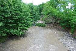
The Topolog is a left tributary of the river Olt in Romania.[1][2][3] It discharges into the Olt in Galicea. It is formed by two source rivers that come from the southern slopes of the Făgăraș Mountains: Negoiu and Scara. It flows through the communes Sălătrucu, Șuici, Cepari, Tigveni, Ciofrângeni, Poienarii de Argeș, Milcoiu, Nicolae Bălcescu and Galicea. Including its longest source river, Negoiu, its total length is 111.5 km (69.3 mi) and its basin size is 546.3 km2 (210.9 sq mi).[2][4] For much of its length it forms the border between the counties Argeș and Vâlcea.
| Topolog | |
|---|---|
 | |
| Location | |
| Country | Romania |
| Counties | Argeș, Vâlcea |
| Physical characteristics | |
| Source | Făgăraș Mountains |
| • location | confluence of headwaters Negoiu and Scara |
| • elevation | 1,340 m (4,400 ft) |
| Mouth | Olt |
• location | Galicea |
• coordinates | 44.9424°N 24.2647°E |
• elevation | 184 m (604 ft) |
| Length | 111.5 km (69.3 mi) |
| Basin size | 546.3 km2 (210.9 sq mi) |
| Basin features | |
| Progression | Olt→ Danube→ Black Sea |
Tributaries
The following rivers are tributaries to the river Topolog (from source to mouth):[2]
- Left: Negoiu, Izvorul Podeanului, Marginea, Cumpăna, Valea Plopilor, Valea Satului
- Right: Scara, Mâzgavu, Izvorul Coastelor, Topologel, Cărpeniș, Bădislava, Ciutești, Șerbăneasa
gollark: PotatOS is at present configured to not EZCopy™ things on SC.
gollark: You should install signs on the modems though.
gollark: I won't comment further at this time.
gollark: Also, possible slogan for free tier: "Free to enjoy the potatOS experience™".
gollark: Sorry for any inconvenience caused but not very much.
References
- "Planul național de management. Sinteza planurilor de management la nivel de bazine/spații hidrografice, anexa 7.1" (PDF, 5.1 MB). Administrația Națională Apele Române. 2010. pp. 714–715.
- Atlasul cadastrului apelor din România. Partea 1 (in Romanian). Bucharest: Ministerul Mediului. 1992. p. 298. OCLC 895459847. River code: VIII.1.151
- Plan de apărare în cazul producerii unei situații de urgență specifice (seisme și/sau alunecări de teren) al comitetul județean pentru situații de urgență Vâlcea, p. 91 (in Romanian)
- Bazinul hidrografic Topolog. Studiu geomorfologic, Andreea Andra (2007) p. 19 (in Romanian)
This article is issued from Wikipedia. The text is licensed under Creative Commons - Attribution - Sharealike. Additional terms may apply for the media files.