Tolt River
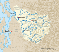
The Tolt River is located in the western foothills of the Cascade Mountains in north central King County in the U.S. state of Washington. The river begins at the confluence of the North Fork Tolt and South Fork Tolt rivers. It flows southwest joining the Snoqualmie River near Carnation, Washington. The Tolt River watershed is part of the larger Snohomish River and Puget Sound drainage basin.
| Tolt River | |
|---|---|
 Map of the Tolt River highlighted in the Snohomish River watershed | |
| Location | |
| Country | United States |
| State | Washington |
| County | King |
| Physical characteristics | |
| Source | North Fork Tolt River |
| • coordinates | 47°41′44″N 121°49′14″W[1] |
| Mouth | Snoqualmie River |
• coordinates | 47°38′24″N 121°55′25″W[1] |
| Discharge | |
| • location | USGS gage 12148500, near Carnation, WA[2] |
| • average | 572 cu ft/s (16.2 m3/s)[2] |
| • minimum | 53 cu ft/s (1.5 m3/s) |
| • maximum | 11,400 cu ft/s (320 m3/s) |
The South Fork Tolt watershed provides ~30% of the drinking water for Seattle area residents.
Name origin
The name Tolt comes from the Lushootseed village name /túlq/.[3]
gollark: I AM to consume blue cheese.
gollark: Je voudrais un sandwich au fromagé et au jambon.
gollark: Ich möchte zwei Äpfel.
gollark: IT IS NOT SAFE
gollark: DO NOT READ THE PINS
See also

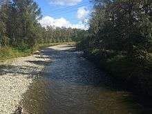
The Tolt River, from the trail bridge over it in Tolt MacDonald Park, in Carnation, Washington
- List of rivers of Washington
References
- U.S. Geological Survey Geographic Names Information System: Tolt River
- "Water Resources Data-Washington Water Year 2005; Snohomish River Basin" (PDF). USGS. Retrieved 5 August 2009.
- Bright, William (2004). Native American placenames of the United States. University of Oklahoma Press. p. 504. ISBN 978-0-8061-3598-4. Retrieved 11 April 2011.
This article is issued from Wikipedia. The text is licensed under Creative Commons - Attribution - Sharealike. Additional terms may apply for the media files.