Toketee Falls
Toketee Falls is a waterfall in Douglas County, Oregon, United States, on the North Umpqua River at its confluence with the Clearwater River.[1][2] It is located approximately 58 miles (93 km) east of Roseburg near Oregon Route 138.[3]
Toketee (pronounced TOKE-uh-tee), is a Chinook Jargon word meaning "pretty" or "graceful".[2] The falls was officially named by a United States Board on Geographic Names decision in 1916, over alternate names Ireland Falls and Toketie Falls.[1]
Description
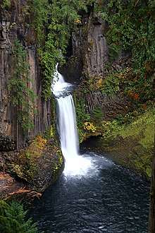
Carved from ancient columnar basalt, Toketee Falls drops approximately 120 feet (37 m) in two stages.
With a reliable water flow on the North Umpqua River, the falls avoids the seasonal fluctuations of other creek-fed waterfalls in Oregon.
Hydropower plant
The waterfall is regulated by a dam built just upstream by PacifiCorp, which now regulates and reduces the water flow over the falls. The damming forms a reservoir called Toketee Lake.[2] Previously the full volume of the North Umpqua River was allowed to flow over the falls, but the flow has been reduced by a penstock that utilizes the drop of the falls to generate hydroelectricity.
Post office
There was a Toketee Falls, Oregon post office from 1952 to 1956 during the construction of the PacifiCorp hydroelectric plant.[2]
References
- "Toketee Falls". Geographic Names Information System. United States Geological Survey. November 28, 1980. Retrieved March 5, 2012.
- McArthur, Lewis A.; McArthur, Lewis L. (2003) [1928]. Oregon Geographic Names (7th ed.). Portland, Oregon: Oregon Historical Society Press. pp. 960–961. ISBN 978-0875952772.
- Oregon Atlas & Gazetteer (7th ed.). Yarmouth, Maine: DeLorme. 2008. pp. 53–54. ISBN 0-89933-347-8.
External links
