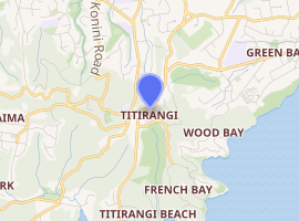
Titirangi
Titirangi is a suburb in the Waitākere Ward of the city of Auckland in northern New Zealand. It is an affluent, residential suburb located 13 kilometres (8 miles) to the southwest of the Auckland city centre, at the southern end of the Waitākere Ranges.[1] In the Māori language "Titirangi" means "long streaks of cloud in the sky", but this is often given as "fringe of heaven".[2][3]
Titirangi | |
|---|---|
Suburb | |
| |
| Country | New Zealand |
| Local authority | Auckland Council |
| Electoral ward | Waitākere Ward |
| Population (2018) | |
| • Total | 7,203 |
| Konini | Glen Eden | New Lynn |
| Oratia |
|
Green Bay |
| Laingholm | (Manukau Harbour) | (Manukau Harbour) |
Demographics
| Year | Pop. | ±% p.a. |
|---|---|---|
| 2006 | 6,375 | — |
| 2013 | 6,642 | +0.59% |
| 2018 | 7,203 | +1.63% |
| Source: [4] | ||
Titirangi, comprising the statistical areas of West Lynn and Titirangi South, had a population of 7,203 at the 2018 New Zealand census, an increase of 561 people (8.4%) since the 2013 census, and an increase of 828 people (13.0%) since the 2006 census. There were 2,469 households. There were 3,570 males and 3,633 females, giving a sex ratio of 0.98 males per female, with 1,470 people (20.4%) aged under 15 years, 1,155 (16.0%) aged 15 to 29, 3,645 (50.6%) aged 30 to 64, and 933 (13.0%) aged 65 or older.
Ethnicities were 83.4% European/Pākehā, 8.0% Māori, 5.4% Pacific peoples, 12.4% Asian, and 2.9% other ethnicities (totals add to more than 100% since people could identify with multiple ethnicities).
The proportion of people born overseas was 30.9%, compared with 27.1% nationally.
Although some people objected to giving their religion, 56.6% had no religion, 28.8% were Christian, and 7.8% had other religions.
Of those at least 15 years old, 2,052 (35.8%) people had a bachelor or higher degree, and 555 (9.7%) people had no formal qualifications. The employment status of those at least 15 was that 3,150 (54.9%) people were employed full-time, 867 (15.1%) were part-time, and 213 (3.7%) were unemployed.[4]
Geography
Titirangi is bordered to the south by Manukau Harbour, to the west and north west by the rest of the Waitākere Ranges' native bush clad hills consisting of the large Centennial Memorial Park and water catchment areas which supply much of Auckland's water. The main road into the Waitakeres, the Scenic Drive, begins in Titirangi. To the east and north are a number of more urban suburbs.
The Waitākere Ranges lie on the west coast of the North Island in the path of the prevailing winds from the Tasman and consequently attract a high rainfall. The native bush is home to many native birds, such as the fantail, tui, kereru or "wood pigeon", morepork and white-eye, and geckos and rare native frogs. The landscape of Titirangi ranges from Titirangi Beach on the Manukau Harbour to 400 metre (1300') high parts of the Waitākere Ranges.
Mt Atkinson is in the foothills of Titirangi, not far from the village centre. There is a short scenic walk, with expansive views of Titirangi Village and the Manukau and Waitemata harbours. There is also 'Zig Zag Track' walk, which winds its way through native bush from the village centre to Titirangi Beach. Exhibition Drive, a well-formed track very popular with walkers, joggers and cyclists, is located 1.5 km (1 mile) from the village centre.
Culture
Titirangi is characterised by houses built within the native bush of the Waitākere Ranges, sometimes with views of the Manukau Harbour. Some of the residential properties are of unusual design. For instance, some houses were raised on poles so that they could be built in the bush without harming the roots of trees surrounding the house.[5]
The name "Titirangi" is often linked with Titirangi Golf Course. The course is actually located on the border of the nearby suburbs of New Lynn and Green Bay. Other areas surrounding Titirangi include Oratia, Nihotupu, Glen Eden, Woodlands Park, Laingholm and Waiatarua.
For a long time the area had a reputation for bohemianism.[6] A number of well known New Zealand musicians, artists, writers and potters currently live or have lived in the area, including singer/songwriter Tim Finn (who wrote the song "I Hope I Never" there), actress Alma Evans-Freake, author Maurice Shadbolt, painter Colin McCahon (whose house is preserved as a museum and residence for artists and writers), feminist artist Alexis Hunter, photographer Brian Brake, poet John Caselberg, potter Len Castle and glass artist Ann Robinson.
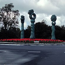
The sculpture on the round-about connecting Titirangi Road, Atkinson Road, Kohu Road, Scenic Drive and Huia Rd has been a symbol of Titirangi for many years, although it is a controversial presence. Designed by student artist-jeweller Lisa Higgins in 1993, it was originally erected with the intention of only being in place for five years but has remained permanently.[7] This was part of a Waitakere City Council programme of involving artists in public developments.[8] Its original pink colour was toned down to a teal green in 2009.[7]
An active local theatre, cinema, community art gallery and radio station are based in historic Lopdell House.[9] Located next door, Te Uru Waitakere Contemporary Gallery is West Auckland's regional art gallery.[10] Many short walks or tramps in the Waitakeres start from Titirangi.
Education
Titirangi School is a coeducational contributing primary (years 1-6) school with a roll of 429 as of March 2020.[11][12] The school celebrated its centenary in 1972,[13] although the history of the school goes back to around 1845.[14]
The nearest state secondary schools are Green Bay High School, Kelston Boys' High School and Kelston Girls' College.
Notes
- Gregory's Auckland & Surrounds Street Directory (3rd ed.). 2008. p. map 104. ISBN 978-0-7319-2048-8.
- Alexander Wyclif Reed (1975). Place names of New Zealand. p. 425. ISBN 0-589-00933-8.
- Discover New Zealand:A Wises Guide (9th ed.). 1994. p. 70.
- "Statistical area 1 dataset for 2018 Census". Statistics New Zealand. March 2020. West Lynn (135400) and Titirangi South (136700). 2018 Census place summary: West Lynn 2018 Census place summary: Titirangi South
- NZ History. "Pole House in Titirangi".
- McClure, M.(2008). "Waitākere Ranges", Te Ara - The Encyclopedia of New Zealand, updated 2 December 2008. Retrieved on 31 March 2008
- "Facelift for iconic sculpture - Waitakere City Council press release". Scoop. Retrieved 26 October 2013.
- Diaz, Deborah (24 September 2000). "Artists take on the West". NZ Herald. Retrieved 20 March 2019.
- "Titirangi Theatre". Archived from the original on 11 May 2016. Retrieved 24 July 2016.
- "Te Uru Waitakere Contemporary Gallery". Retrieved 24 July 2016.
- "New Zealand Schools Directory". New Zealand Ministry of Education. Retrieved 26 April 2020.
- Education Counts: Titirangi School
- Titirangi Primary School Centennial Booklet. 1972. Retrieved 15 May 2009.
- "Titirangi School (BAWT)". Archives New Zealand. Retrieved 15 May 2009.