Tugela River
The Tugela River (Zulu: Thukela; Afrikaans: Tugelarivier) is the largest river in KwaZulu-Natal Province, South Africa. It is one of the most important rivers of the country.[1]
| Tugela Thukela | |
|---|---|
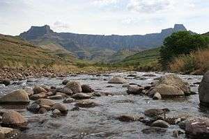
 The Tugela River with the Amphitheatre in the background | |
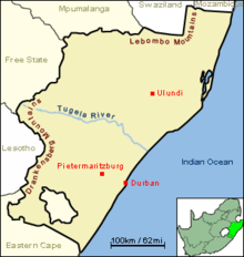
 The course of the Tugela river, from the west to the east border of KwaZulu-Natal. | |
| Location | |
| Country | South Africa |
| Province | KwaZulu-Natal |
| Towns | Bergville, Colenso |
| Physical characteristics | |
| Source | |
| • location | Drakensberg |
| Mouth | Indian Ocean |
| Length | 502 km (312 mi) |
| Basin size | 29,100 km2 (11,200 sq mi) |
The river originates in Mont-aux-Sources of the Drakensberg Mountains and plunges 947 metres down the Tugela Falls. The Mont-aux-Sources is also the origin of tributaries of two other major South African rivers, the Orange and the Vaal. From the Drakensberg range, the Tugela follows a 502 kilometres (312 mi) route through the KwaZulu-Natal midlands before flowing into the Indian Ocean.[2] The total catchment area is approximately 29,100 square kilometres (11,200 sq mi).[2] Land uses in the catchment are mainly rural subsistence farming and commercial forestry.
Tributaries

The Tugela has a number of tributaries coming off the Drakensberg, the largest being the Mzinyathi ("Buffalo") River (rising near Majuba Hill), but also the Little Tugela River, Klip River (rising near Van Reenen Pass), Mooi River, Blood River, Sundays River (rising in the Biggarsberg) Ingagani River and Bushman River.[2][3] The Buffalo River joins the Tugela some 19 kilometres (12 mi) east of Tugela Ferry at 28°43′04″S 30°38′41″E.
The Blood River was named by the Boers, led by Andries Pretorius, after they defeated the Zulu king Dingane on 16 December 1838, when the river is said to have run red with the blood of Zulu warriors. Below the Blood River is Rorke's Drift, a crossing point and a battle site, in the Anglo-Zulu War.
Ecology
The Scaly Yellowfish (Labeobarbus natalensis) is found in the Tugela River System. It is a common endemic fish in KwaZulu-Natal Province and it is found in different habitats between the Drakensberg foothills and the coastal lowlands, including rivers such as the Umkomazi.[4]
Spelling
The spelling "Tugela" was used for most of the twentieth century; it is an Anglicised version of the Zulu name Thukela. Nineteenth-century writers adopted a variety of spellings including:
- Isaacs (1836) used a number of different spellings in his book, Travels and Adventures in Eastern Africa,[5] including "Ootergale" and "Ootoogale".
- C.R. Maclean (John Ross), writing in the Nautical Magazine in 1853, used the spelling Zootagoola[6]
- Angus, a nineteenth-century artist, used the name "Tugala" on the captions to his sketches.[7]
Some of the variations can be accounted for by the early European writers being unaware that Zulu grammar uses prefixes, often a "i-" or a "u-", to denote the noun class of a noun.

See also
- List of rivers in South Africa
- Dams on the Tugela
- Driel Barrage Dam
- Spioenkop Dam
- Woodstock Dam
Notes
- "Key rivers of South Africa". MyFundi. Archived from the original on 2012-07-10.
- "Proposal to establishment a Catchment Management Agency for the Thukela Water Management Area - Appendix A" (PDF). Department of Water Affairs and Forestry. July 2004. Retrieved 2008-10-21.
- Thukela WMA 7
- "Technical Report on the State of Yellowfishes in South Africa 2007" (PDF). Archived from the original (PDF) on 2017-06-29. Retrieved 2012-03-29.
- Nathaniel Isaacs (1836). Travels and Adventures in Eastern Africa - Vol I. Edward Churton. Retrieved 2010-08-08.
- C.R. Maclean (February 1853). "Loss of the Brig Mary at Natal with Early Recollections of that Settlement - Two". The Nautical Magazine. pp. 74–80. Reproduced in Stephen Gray (ed.). The Natal Papers of John Ross. ISBN 978-0-869-80851-1.
- "Making outchoualla or native beer, at Gudu's kraal, Tugala River, Zulu country", a sketch by G F Angus; National Library of Australia.