Theodore Roosevelt Lake Bridge
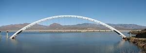
The Theodore Roosevelt Lake Bridge is a vehicular bridge traversing Theodore Roosevelt Lake between Gila County and Maricopa County, Arizona. Prior to its completion, traffic on Arizona SR 188 travelled directly on top of the Theodore Roosevelt Lake Dam.[2][3] The dam was originally designed to accommodate the width of two Ford Model-T automobiles, and had to be later reduced to a single lane road due increased vehicle widths.
Theodore Roosevelt Lake Bridge | |
|---|---|
 | |
| Coordinates | 33°40′26″N 111°9′25″W |
| Carries | Two lanes of |
| Crosses | Theodore Roosevelt Lake |
| Locale | Gila County - Maricopa County, Arizona |
| Maintained by | AZDOT |
| ID number | AZ 2028 |
| Characteristics | |
| Design | Single Span Steel Arch bridge |
| Total length | 2,198.9 ft (670.2 m)[1] |
| Width | 37.7 ft (11.5 m) |
| Longest span | 1,079.8 ft (329.1 m)[1] (tied-arch span) |
| History | |
| Opened | 1992[1] |
| Statistics | |
| Daily traffic | 1,522 (2014) |
Per the United States Bureau of Reclamation, in 1995, along with other notable bridges such as the Brooklyn Bridge and Golden Gate Bridge, the bridge was listed by the American Consulting Engineers Council as one of top twelve bridges designs in the United States,[2] and is currently the "longest two-lane, single-span, steel-arch bridge in North America".[2] The build contract was awarded to Edward Kraemer & Sons, Inc. of Plain, Wisconsin,[1] with an overall total cost of $21.3 million USD in 1992. [2]
References
- Bridge Hunter, Roosevelt Lake Bridge, Bridge Hunter, retrieved December 28, 2019
- Phoenix Area Office (June 25, 2015), A Brief History of Roosevelt Dam, United States Bureau of Reclamation, retrieved December 28, 2019
- Thornton-O'Connell, Jodi (August 6, 2018), "The History of Roosevelt Lake in Arizona", USA Today, retrieved December 28, 2019