Texas State Highway Spur 37
State Highway Spur 37 (Spur 37) is a 1.1-mile-long (1.8 km) spur route in El Paso County, Texas.[1]
| ||||
|---|---|---|---|---|
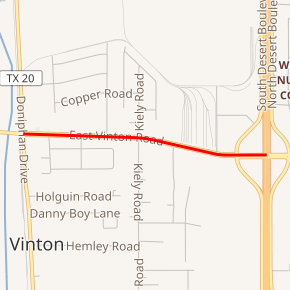
Spur 37 highlighted in red | ||||
| Route information | ||||
| Maintained by TxDOT | ||||
| Length | 1.1 mi[1] (1.8 km) | |||
| Existed | 2005–present | |||
| Major junctions | ||||
| West end | ||||
| East end | ||||
| Location | ||||
| Counties | El Paso | |||
| Highway system | ||||
| ||||

Route description
The western terminus of Spur 37 is at SH 20 (Doniphan Rd.) in Vinton. The route travels east along Vinton Rd. before ending at exit 2 on I-10.[1][2]
History

The number originally belonged to Loop 37 designated on September 25, 1939, which went from US 82 in Avery along Houston Ave, Texas Ave, and Dallas Ave to US 82. On June 21, 1990, this route was transferred to BU 82-K.
Spur 37 was established on June 30, 2005.[1]
Major intersections
The entire route is in Vinton, El Paso County.
| mi[1] | km | Destinations | Notes | ||
|---|---|---|---|---|---|
| 0.0 | 0.0 | ||||
| 1.1 | 1.8 | Exit 2 (I-10) | |||
| 1.000 mi = 1.609 km; 1.000 km = 0.621 mi | |||||
gollark: <@107118134875422720> That can't be used to carry information, and I think is specific to one interpretation of quantum mechanics.
gollark: Urine is slower than light.
gollark: Wait, what?
gollark: * is according to you and nobody else
gollark: It's not a frequency.
See also


References
- Transportation Planning and Programming Division (n.d.). "State Highway Spur No. 37". Highway Designation Files. Texas Department of Transportation.
- Transportation Planning and Programming Division (2012). Texas County Mapbook (PDF) (Map) (2012 ed.). 1:120,000. Texas Department of Transportation. p. 70. OCLC 867856197. Retrieved 2011-09-22.
External links
![]()
This article is issued from Wikipedia. The text is licensed under Creative Commons - Attribution - Sharealike. Additional terms may apply for the media files.