Texas State Highway 352
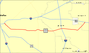
State Highway 352 (SH 352) is a Texas state highway running from Dallas east through Mesquite before finally ending in Sunnyvale. The route mainly runs along Scyene Rd. The highway was designated on October 6, 1943 from U.S. Highway 80 in Mesquite west to U.S. Highway 175 southeast of Dallas, replacing part of SH 183 when it was relocated to the north, and was extended into Dallas on February 17, 1964 when US 175 was relocated to the west. On June 25, 1991, the section of SH 352 from I-30 to the old route of US 80 was cancelled and removed from the state highway system.
| ||||
|---|---|---|---|---|
 | ||||
| Route information | ||||
| Maintained by TxDOT | ||||
| Length | 13.619 mi[1] (21.918 km) | |||
| Existed | 1943–present | |||
| Major junctions | ||||
| West end | ||||
| East end | ||||
| Highway system | ||||
| ||||
.jpg)
Part of State Highway 352 runs in front of the State Fair of Texas, over a stretch named Robert B. Cullum Boulevard.
Route description
SH 352 begins 0.4 miles east of I-30 in Dallas at the corner of 1st Avenue and Parry Avenue adjacent to Dallas Fair Park, and it heads east through Dallas to an intersection with Loop 12. The highway continues to the east to an intersection with I-635 in Mesquite. SH 352 reaches its eastern terminus at US 80 in Sunnyvale.[2]
Major junctions
The entire route is in Dallas County.
| Location | mi[2] | km | Destinations | Notes | |
|---|---|---|---|---|---|
| Dallas | 0.000 | 0.000 | Western terminus | ||
| 5.6 | 9.0 | Interchange; eastbound exit only | |||
| Mesquite | 9.3 | 15.0 | Exit 4 (I-635) | ||
| 10.7 | 17.2 | Belt Line Road | |||
| Sunnyvale | 13.619 | 21.918 | Eastern terminus; continues north as Collins Road | ||
| 1.000 mi = 1.609 km; 1.000 km = 0.621 mi | |||||
References
- Transportation Planning and Programming Division (n.d.). "State Highway No. 352". Highway Designation Files. Texas Department of Transportation. Retrieved April 2, 2008.
- Google (September 7, 2012). "Texas State Highway 352" (Map). Google Maps. Google. Retrieved September 7, 2012.
