Texas State Highway 347
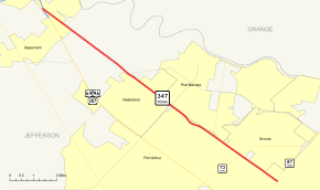
State Highway 347 (SH 347) is a Texas state highway that runs northwest from Port Arthur to the southern edge of Beaumont. The highway is signed south-north. It was designated on November 25, 1942 along the old route of US 69.
| ||||
|---|---|---|---|---|
 | ||||
| Route information | ||||
| Maintained by TxDOT | ||||
| Length | 11.441 mi[1] (18.413 km) | |||
| Existed | 1942–present | |||
| Major junctions | ||||
| South end | ||||
| North end | ||||
| Highway system | ||||
| ||||

Route description
SH 347 begins at SH 87 in Port Arthur. The highway heads northwest, crossing SH 73, Spur 136 and FM 365. SH 347 then enters Nederland and has a junction with FM 366. Continuing northwest, the highway enters Beaumont and ends at US 69/US 96/US 287 in the southern end of the city at Spur 380 ( Martin Luther King Jr. Parkway)
Junction list
The entire route is in Jefferson County.
| Location | mi | km | Destinations | Notes | |
|---|---|---|---|---|---|
| Port Arthur | |||||
| Interchange | |||||
| | |||||
| | |||||
| Beaumont | Interchange | ||||
| 1.000 mi = 1.609 km; 1.000 km = 0.621 mi | |||||
gollark: Oh wait, it should already have it.
gollark: Want me to give RADIOMETRIC FALSITY access?
gollark: Done.
gollark: Heavpoot was working on it.
gollark: And what happened to wordmarket?
References
- Transportation Planning and Programming Division (n.d.). "State Highway No. 347". Highway Designation Files. Texas Department of Transportation. Retrieved 2008-04-02.
This article is issued from Wikipedia. The text is licensed under Creative Commons - Attribution - Sharealike. Additional terms may apply for the media files.