Teshel Cove
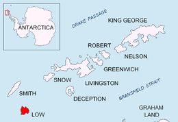
Teshel Cove (Bulgarian: залив Тешел, ‘Zaliv Teshel’ \'za-liv 'tr-shel\) is the 1.4 km wide cove indenting for 1.6 km the west coast of Low Island in the South Shetland Islands, Antarctica. Situated north of Malina Cove and south by west of Kazichene Cove, 8.3 km north of Cape Garry and 6.7 km south by west of Cape Wallace.

Location of Low Island in the South Shetland Islands.
The cove is named after the settlement of Teshel in southern Bulgaria.
Location
Teshel Cove is centred at 63°17′17″S 62°15′08″W. British mapping in 2009.
Maps
- South Shetland Islands: Smith and Low Islands. Scale 1:150000 topographic map No. 13677. British Antarctic Survey, 2009.
- Antarctic Digital Database (ADD). Scale 1:250000 topographic map of Antarctica. Scientific Committee on Antarctic Research (SCAR). Since 1993, regularly upgraded and updated.
gollark: Not weird key-exchange issues or whatever.
gollark: Weird. In my experience SSH either just doesn't work at all because I broke it somehow, denies me access for some reason, or works fine.
gollark: And the hinge rotates 180 degrees, but the panel is a 1366x768 TN one with awful viewing angles.
gollark: The designers of this made some very strange design choices, I must say. It came with soldered RAM, but also a SODIMM slot.
gollark: My laptop's a cheap refurbished business-y one which I upgraded with a SSD and more RAM, and it works *okay*.
References
- Teshel Cove. SCAR Composite Gazetteer of Antarctica.
- Bulgarian Antarctic Gazetteer. Antarctic Place-names Commission. (details in Bulgarian, basic data in English)
External links
- Teshel Cove. Copernix satellite image
This article includes information from the Antarctic Place-names Commission of Bulgaria which is used with permission.
This article is issued from Wikipedia. The text is licensed under Creative Commons - Attribution - Sharealike. Additional terms may apply for the media files.