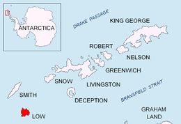
Kazichene Cove
Kazichene Cove (Bulgarian: залив Казичене, romanized: zaliv Kazichene, IPA: [ˈzalif kɐˈzit͡ʃɛnɛ]) is a 2.2 km wide cove on the southeast side of Osmar Strait indenting for 1.3 km the northwest coast of Low Island in the South Shetland Islands, Antarctica. It is esouth of Lyutibrod Rocks and Fernandez Point, and north of Solnik Point.

Location of Low Island in the South Shetland Islands.
The cove is named after the settlement of Kazichene in western Bulgaria.
Location
Kazichene Cove is centred at 63°15′18″S 62°13′40″W. British mapping in 2009.
Maps
- South Shetland Islands: Smith and Low Islands. Scale 1:150000 topographic map No. 13677. British Antarctic Survey, 2009.
- Antarctic Digital Database (ADD). Scale 1:250000 topographic map of Antarctica. Scientific Committee on Antarctic Research (SCAR). Since 1993, regularly upgraded and updated.
gollark: *nothing whatsoever happens*
gollark: CC will just replace invalid stuff with ?.
gollark: Unicode has accursedly complex rules, CC is just "lololol draw colored bitmap into fixed-size screen regions".
gollark: 1. I doubt this2. Unicode rendering is hard, CC rendering is not.
gollark: It might make a receiving computer print weird things, at worst.
References
- Kazichene Cove. SCAR Composite Gazetteer of Antarctica.
- Bulgarian Antarctic Gazetteer. Antarctic Place-names Commission. (details in Bulgarian, basic data in English)
External links
- Kazichene Cove. Copernix satellite image
This article includes information from the Antarctic Place-names Commission of Bulgaria which is used with permission.
This article is issued from Wikipedia. The text is licensed under Creative Commons - Attribution - Sharealike. Additional terms may apply for the media files.