Te Whaiti
Te Whaiti or Te Whāiti is a forested area in the Whakatane District and Bay of Plenty Region of New Zealand's North Island. It is located in the Whirinaki River Valley, near Minginui.[1]
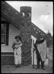
Chief Matekuare and his daughter Tuki outside a meeting house in Te Whaiti
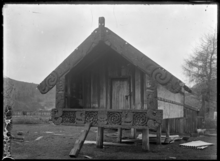
Carved pataka (storehouse) at Te Whaiti photographed in 1930
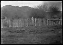
Fencing at the house of Te Kooti at Te Whaiti in 1930
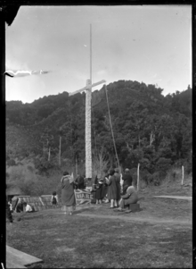
Dedication ceremony at Waireporepo Pa
The area's full Māori name, Te Whāiti-nui-a-Toi, translates as "the great canyon of Toi".[2]
Albert Percy Godber took photographs of Māori art and architecture in the area.[3]
Te Whaiti is in the rohe (tribal area) of both Tūhoe and Ngāti Whare. It has three marae:[4][5]
- Waikotikoti Marae and Hinenuitepo meeting house is affiliated with the Tūhoe hapū of Te Karaha, Ngāti Hāmua, Warahoe, and with Ngāti Whare.
- Murumurunga Marae and Wharepakau meeting house is affiliated with both iwi.
- Waireporepo Marae is a meeting ground of Ngāti Whare; it has no meeting house.
Education
A school opened in Te Whaiti in 1896.[6]
The school is now Te Kura Maori-a-Rohe o Waiohau, a co-educational state Māori language immersion area school.[7] It has a roll of 60 as of March 2020.[8]
gollark: Did it get cracked or something?
gollark: That looks like a TV we had when someone shot it with a bow and arrow.
gollark: The great thing about having only two data points is that you can easily make models which predict your data perfectly.
gollark: Looks perfectly consistent to me!
gollark: See, THIS is on my 404 page and rotates utterly, as well as changing color.
References
- "Appendix to the Journals of the House of Representatives of New Zealand". House of Representatives. 4 August 1907 – via Google Books.
- Wiri, Robert K. J. (4 August 2001). "The Prophecies of the Great Canyon of Toi: a history of Te Whāiti-nui-a-Toi in the western Urewera Mountains of New Zealand" – via researchspace.auckland.ac.nz.
- "Godber, Albert Percy, 1875-1949 :Collection of albums, prints and negatives". natlib.govt.nz. National Library of New Zealand.
- "Te Kāhui Māngai directory". tkm.govt.nz. Te Puni Kōkiri.
- "Māori Maps". maorimaps.com. Te Potiki National Trust.
- Binney, Judith (4 August 2009). "Encircled Lands: Te Urewera, 1820–1921". Bridget Williams Books – via Google Books.
- "Te Kura Maori-a-Rohe o Waiohau Ministry of Education School Profile". educationcounts.govt.nz. Ministry of Education.
- "Te Kura Maori-a-Rohe o Waiohau Education Review Office Report". ero.govt.nz. Education Review Office.
This article is issued from Wikipedia. The text is licensed under Creative Commons - Attribution - Sharealike. Additional terms may apply for the media files.