Tavkvetili
Mount Tavkvetili (Georgian: თავკვეთილი) is a volcanic mountain in the northern part of the Abul-Samsari Range in the Samtskhe-Javakheti region of Southern Georgia.[2] It is also known as Gora Tavk'vetili and Mta Tavk'vetili. The elevation of the mountain is 2,583 metres (8,474 ft) above sea level and is the 323rd highest mountain in Georgia.[3] The mountain has the shape of a decapitated cone and is composed of young andesitic and andesitic-dacitic lavas. The lower slopes of Mount Tavkvetili are covered by subalpine meadows while the upper slopes are covered by alpine meadows.
| Tavkvetili | |
|---|---|
_1.jpg) Tavkvetili seen from the village of Tabatskuri | |
| Highest point | |
| Elevation | 2,583 m (8,474 ft) |
| Coordinates | 41.6811°N 43.7214°E |
| Geography | |
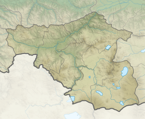 Tavkvetili Location of the mountain  Tavkvetili Tavkvetili (Georgia) | |
| Location | Georgia |
| Parent range | Abul-Samsari Range |
| Geology | |
| Age of rock | Late Pleistocene[1] |
| Mountain type | Stratovolcano |
| Type of rock | Andesite and dacite |
| Last eruption | 8—18 ka ago[1] |
Natural disasters
Mount Tavkvetili has destructive earthquakes around once every 50 years that rank over a 7 on the Richter magnitude scale.[4]
gollark: I mean, authoritarian regimes... aren't very good, I think, even if they can *sometimes* produce good outcomes.
gollark: IIRC China *did* silence people warning about it back in 2019, though.
gollark: Just subtract one from all years. I don't think that could go wrong at all.
gollark: This had better not be an uncomputable algorithm somehow.
gollark: You could generally just put it in code blocks, unless you prevent that somehow.
References
- Georgian State (Soviet) Encyclopedia. 1979. Book 4. p. 569.
- Lordkipanidze, D.; Ferring, R.; Bardintzeff, J. M.; Courtin-Nomade, A.; Renne, P. R.; Voinchet, P.; Mgeladze, A.; Messager, E.; Guillou, H. "New 40Ar/39Ar, unspiked K/Ar and geochemical constraints on the Pleistocene magmatism of the Samtskhe-Javakheti highlands (Republic of Georgia)". Quaternary International. 395: 45–59. ISSN 1040-6182.
- "Gora Tavkvetili".
- "Mta Tavk'vitili".
- "Gora Tavkvetili".
| Wikimedia Commons has media related to Tavkvetili. |
This article is issued from Wikipedia. The text is licensed under Creative Commons - Attribution - Sharealike. Additional terms may apply for the media files.