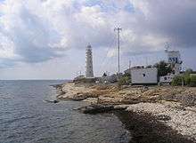
Tarkhankut Peninsula
The Tarkhankut Peninsula (Ukrainian: Тарханкутський півострів, Russian: Тарханкутский полуостров, Crimean Tatar: Tarhanqut yarımadası) is the peninsula which constitutes the western extremity of Crimea into the Black sea. Its northern shore is a southern coast of the Karkinit Bay.[1] Its westernmost point is Cape Priboyny, to the south of it is Cape Tarkhankut. The terrain of the peninsula is the Tarkhankut Highlands.

Cape Tarkhankut

Cape Tarkhankut is a south-western cape of the Tarkhankut Peninsula, Crimea.[2] The Tarkhankut lighthouse is located on the cape.
Tarkhankut Upland
The Tarkhankut Upland or Tarkhankut Hills is an upland that constitutes the Tarkhankut Peninsula.[3] The Tarkhankut Wind Farm is located at the upland.
Wind Farm
The Tarkhankut Wind Farm (Tarkhankut Wind Plant, Ukrainian: Тарханкутська вітряна електростанція) is a wind power plant located at Donuzlav lake on the Tarkhankut Highlands of the Tarkhankut Peninsula, Crimea.
It is the state property. Its construction was contracted to Windenergo Ltd., At the commissioning date of November 30, 2001, 21 wind turbines were installed with total capacity of 2.26 MW. The planned capacity was 70 MW.[4]
Donuzlav
The Donuzlav Lake (Ukrainian: Донузлав) is a salty lake that is connected to the Black Sea via a ship channel and located at the southern shores of the peninsula.
References
- Article "Тарханкутский полуостров" in Great Soviet Encyclopedia
- "Мыс Тарханкут (Тархан-Кут) – самая западная точка Крымского полуострова"
- Article "Тарханкутский полуостров" in Great Soviet Encyclopedia
- THE NATIONAL STRATEGY OF UKRAINE FOR JOINT IMPLEMENTATION AND EMISSIONS TRADING PROJECT PIPELINE Kiev, 2003 (retrieved July 12, 2015)