Tariat
Tariat (Mongolian: Тариат, crop) is a sum (district) of Arkhangai Province in central Mongolia. As of 2009 it had a population of 5086 people (mainly Chalcha) in 2009, 644 of whom lived in the village of Tariat.
Tariat District Тариат сум ᠲᠠᠷᠢᠶ᠋ᠠᠲᠤᠰᠤᠮᠤ | |
|---|---|
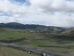 Tariat sum center view from East | |
| Country | Mongolia |
| Province | Arkhangai Province |
| Time zone | UTC+8 (UTC + 8) |
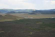
Tariat sum center and lava fields from the Khorgo volcano
Geography
Tariat is located 195 kilometres (121 mi) northwest of Tsetserleg, the capital of the province. To west of the town is Khorgo-Terkhiin Tsagaan Nuur National Park, noted for its striking crater Khorgo.[1][2]
The Chuluut River flows through the district. In 1977 the Soviet geologist Kavel discovered rock images along the river.[3]
Education
The school in Tariat was attended by the Mongolian Social Democratic Party politician Radnaasümbereliin Gonchigdorj.[4]
gollark: Were would be for plural or something, English is weird.
gollark: This is such a bizarre and pointless conversation.
gollark: What did they do, talk about TF2 a bit?
gollark: Yeeeees.
gollark: * hijäcked
References
- Werner Elstner: Mongolei (in German). Berlin 1993, p. 161.
- S. Tsedensodnom, M. Bulgantsetseg, Ts Jargalsaikhan (2006). "Untouched Landscapes of Mongolia". p. 54.CS1 maint: uses authors parameter (link)
- Damdinsu̇rėngiĭn T︠S︡ėvėėndorzh (2004). "Petroglyphs of Javkhlant Mountain". Shinzhlėkh Ukhaany Akademi. p. 112.
- "Mongol Ulsyn Ikh Khural, 1996-2000". Montsame. p. 18.
 | ||
This article is issued from Wikipedia. The text is licensed under Creative Commons - Attribution - Sharealike. Additional terms may apply for the media files.